Overview
The Alberta Wetland Policy provides the strategic direction and tools required to:
- allow for continued growth and economic development in the province
- make informed management decisions in the long-term interest of Albertans
- minimize the loss and degradation of wetlands
The goal of the Alberta Wetland Policy is to conserve, restore, protect and manage Alberta's wetlands to sustain the benefits they provide to the environment, society and economy. To achieve this goal, the policy will focus on 4 outcomes:
- wetlands of the highest value are protected for the long-term benefit of Albertans
- wetlands and their benefits are conserved and restored in areas where losses have been high
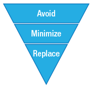
- wetlands are managed by avoiding, minimizing and if necessary, replacing lost wetland value
- wetland management considers regional context
The link to the Alberta Wetland Policy can be found here.
Policy requirements and tools
-
Planning and legislative alignment
Preliminary desktop review
The first step in planning is to perform a preliminary desktop review (see Alberta Wetland Identification and Delineation Directive) to identify all potential wetlands and to consider how wetland avoidance can be achieved in the planning and design of the proposed activity.
Legislative alignment and regulatory authorizations
The next step is to conduct a review of legislation that needs to be met for the activity, including acts, regulations, policies and plans under federal, provincial and municipal jurisdiction.
The following provincial authorizations are required when a proposed activity may have impacts on a wetland:
- a Public Lands Disposition or Approval, where the activity is either located on public land or is within a permanent and naturally occurring body of water under Section 3 of the Public Lands Act
- a Water Act Authorization (Approval, Licence, or Notice) for all activities within a waterbody, unless the activity is exempt under the Water (Ministerial) Regulation
- an Authorization under the Environmental Protection and Enhancement Act, where the proposed activity that will impact a wetland is regulated by this act
Ownership
Section 3 of the Public Lands Act deems that ownership of the bed and shores of permanent and naturally occurring bodies of water in the province belongs to the Government of Alberta.
Enquiries about the ownership to the bed and shore of a body of water can be submitted to:
The department's assessment of ownership must be attached to a Water Act application related to wetlands that may be permanent and naturally occurring bodies of water. Any activity within a crown-owned water body requires departmental approval under the Public Lands Act.
-
Wetland assessment
A proponent proposing an activity that will impact a wetland must submit a wetland assessment to the regulatory body with their application and all other required plans.
Any wetland assessment submitted to the regulatory body must be signed by an authenticating professional (see Wetland Professional Practice Standard section below).
A suite of guides and tools have been developed to support standardized wetland assessments for professionals.
Alberta Wetland Identification and Delineation Directive
This directive provides guidance on how to define a wetland and delineate its ecological extent. The directive also provides submission standards for creating a spatial file of a wetland.
The template below can be used to create a spatial shape file of a wetland:
Alberta Wetland Classification System
The Alberta Wetland Classification System groups wetlands into 5 major classes – bogs, fens, swamps, marshes and shallow open water wetlands – based on common physical, chemical and biological characteristics. The system subdivides each class by their vegetative form and type (for example: water permanence, pH, salinity).
Alberta Wetland Assessment and Impact Report (WAIR)
For the majority of activities that may impact a wetland, a WAIR must be prepared in accordance with the Alberta Wetland Assessment and Impact Report Directive. The report must be signed by an authenticating professional and submitted as part of a regulatory application.
Alberta Wetland Assessment and Impact Form (WAIF)
The WAIF is used to support low risk activities regulated by Environment and Protected Areas (EPA) and the Alberta Energy Regulator (AER). For eligible activities, the form is to be used in place of the WAIR and must be authenticated by a qualified professional and submitted with a regulatory application or notification and all other required plans. Alberta Wetland Rapid Evaluation Tool - Desktop (ABWRET-D) results must be obtained from EPA and attached to this form.
Questions related to EPA regulated activities within wetlands can be submitted to:
Questions related to AER regulated energy resource activities within a wetland can be submitted to:
Alberta Wetland Rapid Evaluation Tool – Actual (ABWRET-A)
ABWRET-A is a standardized method for assessing the function of wetlands using onsite observations and offsite spatial data. The relative value determined by ABWRET-A is used to determine the replacement ratios and costs for wetland replacement where avoidance is not possible. ABWRET-A results must be obtained from EPA and attached with a WAIR.
ABWRET-A is calibrated for 2 broad regions in Alberta: the Parkland-Grassland Natural Regions and the Boreal-Foothills Natural Regions. The appropriate guide and form is determined by the natural region in which the wetland(s) is located. If the project is on the border of two natural regions, the Boreal-Foothills tool should be used if the majority of wetlands are peatlands and the Parkland-Grassland tool should be used if the majority of wetlands are mineral wetlands. The assessment must be completed during the growing season.
Parkland and Prairie Natural Region Wetlands
Boreal and Foothills Natural Region Wetlands
To obtain a relative wetland value for a wetland, submit the wetland shapefile(s) and the completed ABWRET-A Form to:
Alberta Wetland Rapid Evaluation Tool – Desktop (ABWRET-D)
The Alberta Wetland Rapid Evaluation Tool – Desktop (ABWRET-D) was developed to support wetland evaluation for eligible activities that require a WAIF. ABWRET-D results must be obtained from EPA and attached to a WAIF.
Wetland spatial files are used in the calculation and no field assessment is required. Delineation of wetland extent must be completed in accordance with one of the desktop pathways and follow the submission standards outlined in the Alberta Wetland Identification and Delineation Directive.
To obtain a relative wetland value with ABWRET-D, submit the wetland shapefile(s) and the completed ABWRET-D Form to:
-
Wetland mitigation
Proponents must demonstrate appropriate consideration for wetland avoidance and, where avoidance is not feasible, minimization of wetland impacts, in accordance with the Alberta Wetland Mitigation Directive.
Key questions to ask when planning an activity that may impact a wetland are:
Can the wetland impacts be avoided?
Proponents must demonstrate they have made a concerted effort to avoid wetland impacts.
If avoidance is not possible, how can wetland impacts be minimized?
Minimization is the second priority in the mitigation hierarchy when the proponent has demonstrated that avoidance is not possible.
If there is a reclamation requirement, can a commitment be made to reclaim wetland area?
A proponent is not subject to wetland replacement requirements in cases where an authorized activity has an explicit requirement for reclamation, the landscape conditions allow the activity to be reclaimed back to a wetland, and the proponent commits to reclamation back to wetland.
What happens if permanent wetland impacts will occur?
Wetland replacement is required when wetland impacts that cannot be avoided or minimized will result in permanent loss of wetland area. Options for wetland replacement include:
- pay a wetland replacement fee to the Government of Alberta
- undertake permittee-responsible construction or restoration
What should be included in the Wetland Assessment and Impact Report or Form?
Evidence of wetland avoidance, minimization and replacement must be included in the Wetland Assessment and Impact Report or Form.
-
Wetland replacement
When wetland impacts cannot be avoided or minimized, and will result in permanent loss of wetland area, proponents can fulfil their replacement obligations through one of the following options.
- Permittee-responsible replacement: A proponent can undertake their own wetland replacement project to restore a previously drained wetland or construct a new wetland.
- Pay a wetland replacement fee for the permanent loss of wetland area and relative wetland value, following the instructions in the form:
- Wetland Replacement Fee Form – Updated
Wetland replacement fee process
The following outlines the steps to pay a wetland replacement fee for permanent wetland loss:
- The proponent follows the standard Water Act application process for wetland impacts regulated by EPA and AER.
- If the regulatory body agrees, in principle, to the proposed permanent impacts, the proponent will make a payment to the Government of Alberta according to the instructions on the Wetland Replacement Fee Form. The proponent must not make a payment until directed to do so by EPA or AER.
- The Government of Alberta reviews the wetland replacement fee information and sends a receipt of payment to the proponent.
Wetland Replacement Program
The Wetland Replacement Program (WRP) aims to re-establish wetlands in partnership with Albertans by providing resources for collaborative restoration projects across the province.
Under the Alberta Wetland Policy, WRP will offset wetland habitat lost due to development activities. A priority of the Alberta Wetland Policy and WRP is to replace wetlands within municipalities and watersheds that have had the highest amount of lost wetland area and value since 2015, as well as areas of high historical loss.
Municipalities and non-profits can apply for wetland replacement or restoration funding and project support at:
-
Application submission
Activities regulated by EPA
Any activity that may impact a wetland requires either a Water Act approval or a Code of Practice Notice, unless the activity is exempt under the Water (Ministerial) Regulation.
For any activity impacting a wetland that requires a Public Lands Act disposition, proponents are required to submit an application through the Electronic Disposition System (EDS) with a cover letter indicating that their Public Land Act application has an associated Water Act application that will require either a Wetland Assessment and Impact Report or Form.
- For information on how to submit a Public Lands Act disposition application, please see:
EPA application systems
Questions related to Alberta Wetland Policy implementation for AER regulated energy resource activities within a wetland can be submitted to:
-
Wetland Authenticating Professionals
As of May 1, 2017, EPA requires authenticating professional signoff on regulatory documents submitted under the Alberta Wetland Policy.
Learn more about Wetland authenticating professionals.
-
Additional resources and planning tools
Stepping Back from the Water: A beneficial management practices guide for new development near water bodies in Alberta's settled region.
Alberta Merged Wetland Inventory: The inventory digitally depicts wetlands for the 5 major classes in the Canadian Wetland Classification System: bog, fen, marsh, swamp and shallow open water.
The AMWI should be used for high level planning and not to plan an activity without doing a formal wetland assessment. To do a search, use the keywords “Alberta Merged Wetland”.
The Merged Wetland Inventory Status Map summarizes the data sources and resolutions for different portions of the province.
The Alberta Wetland Mapping Standards and Guidelines: Mapping Wetlands at an Inventory Scale is intended to be used by those in Alberta that have a professional interest in/or are working on wetland conservation and management, including, wetland mapping and inventory development. These were developed based on minimum standards and guidelines to promote consistency and improve data quality in wetland mapping at a provincial scale within the Prairie/Parkland and Boreal/Foothills zones of Alberta.
-
Fact sheets
Fillable PDF forms may not open properly on some mobile devices and web browsers. See the step-by-step guide or contact PDF form technical support.
Disclaimer
The information on these web pages was created to be consistent with Legislation, Policies, Orders in Council, Ministerial Orders, Treaties / Agreements, Frameworks, Strategies, Plans, Codes of Practice and other approved documents which provide direction on implementing legislation. If there is inconsistency between the regulatory documents and this information, the regulatory documents shall prevail.
Contact
Questions related to the Alberta Wetland Policy can be submitted to:
Email: [email protected]
Questions related to the Alberta Water Act can be submitted to the regional Environment and Protected Areas office.
Questions related to AER regulated energy resource activities within a wetland, can be submitted to:
Email: [email protected]