What’s new
In previous versions of AGRASID, land system spatial data was implicit in the classification of AGRASID soil landscape polygons by the land system to which they each belonged. Land system spatial data was generated “on the go” through a spatial dissolve process.
This has changed. Land systems in AGRASID are now available for download as a separate spatial layer. Land system attributes at a soil landscape scale are also available for download in a table called “ag41sl2ag41lslg”.
Figure 1: Structure of the land system spatial data
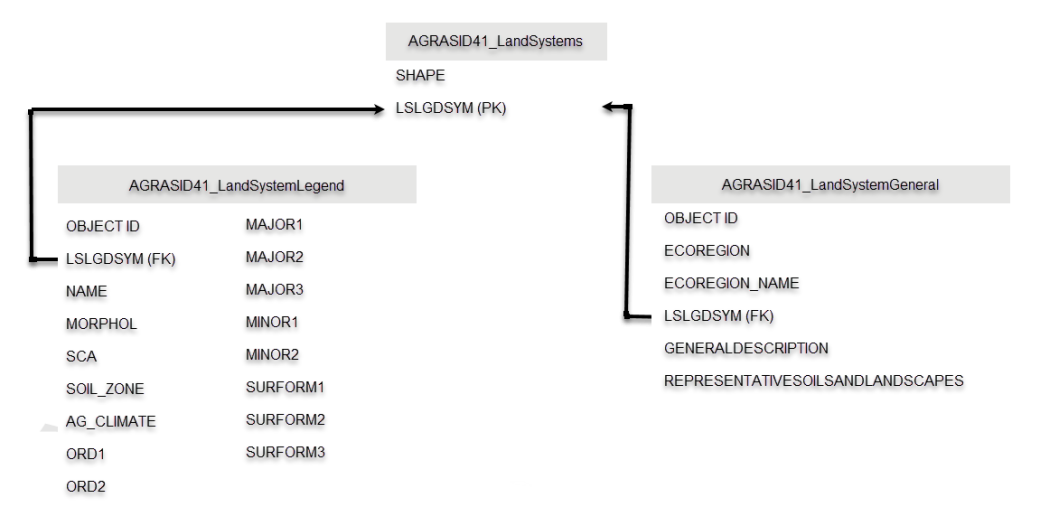
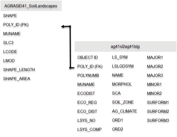
Figure 2. Structure of the Land System spatial data within AGRASID
The files
Here are brief descriptions of the land system files.
GIS data layers
The Land system layer is available at a regional scale in the form of land system polygons and at the landscape scale in the form of soil landscape polygons. The primary and foreign key “LSLGDSYM” is the database attribute that joins land system spatial data “AGRASID41_ LandSystems” to the tables “AGRASID41_LandSystemLegend” “AGRASID41_LandSystemGeneral”. Lists and brief descriptions of the attributes for each land system polygon are available in appendix 2.
Similarly, a list of land system attributes table associated with AGRASID soil landscape polygons is available in appendix 1. The GIS layer of soil information is geo-referenced to the 1:20,000 provincial digital base layers with a projection of 10-degree Transverse Mercator (10TM), NAD 83 (“ArcGIS: NAD_1983_10TM_AEP_Forest” or EPSG: 3400).
Both layers are seamless for the entire white area of the province.
Soil landscape attributes
The AGRASID soil landscape to land system attribute table “ag41sl2ag41lslg” contains data depicting the following:
- ecological attributes
- landscape features
- soil landscape model symbol of each soil polygon
Each soil landscape polygon links to a land system “LSLGDSYM” variable. The variable LS_SYM (created by concatenating the values in the ECO_REG, ECO_DIST, LSYS_NO, and LS_COMP fields) identifies each spatially distinct and unique land system polygon. A land system polygon derives from two or more soil landscape polygons dissolving and merging into larger polygons according to like LS_SYM values. Land systems are “nested and exact” with respect to the 1:100,000-scale soil landscape polygons meaning that a land system completely exactly contains a collection of AGRASID soil landscapes with the same LS_SYM values.
In a similar fashion, creation of Ecoregion and Ecodistrict polygons for the white area of the province is feasible by dissolving AGRASID soil landscapes that have the same ECO_REG values or the same ECO_DIST values within the ag41sl2ag41lslg table.
The covered area of the province would be partial only, and the detail of the resulting boundaries would exceed the intended scale requirements of the Ecoregion and Ecodistrict polygons. The scale of Ecoregion and Ecodistrict polygons is between 1: 2 000 000 and 1: 5 000 000 (see Table 1 of A National Ecological Framework for Canada 1995) much smaller than the AGRASID soil landscape polygons design scale of 1:100,000.
For this reason, the land systems described here are nested but not exact with respect to the ecological maps in the 1995 National Ecological Framework publication. Ecoregion and Ecodistrict maps and the more recent Soil Landscape of Canada polygons that display at a scale of 1:1 000 000 or smaller.
Land system description
Three files describe the soils and landscape characteristics of the recognized land systems within AGRASID. These are:
Land System Legend Table
For more information about the AGRASID41_LandSystemLegend files contained within the AGRASID 4.1 download, see Appendix 1 and Appendix 2.
- Appendix 2 Table 4 – The structure of the AGRASID41_LandSystemLegend attributes data – provides a complete list of the attributes used to describe and characterize each land system in a manner enabling analysis by GIS.
Land systems descriptions
This guide provides a summary of the coded data in human readable text format. Often this information is useful in the creation of hardcopy reports. Access in a GIS environment is possible with this file as well. For more information about the AGRASID41_LandSystemGeneral file contained within the AGRASID 4.1 download, see Appendix 2 Table 5.
The General land systems descriptions for the agricultural regions of Alberta are also available for download in adobe reader format.
Additional files
The following AGRASID files provide additional information about the identified soils within each land system.
They translate and describe the soil-name symbol contained within the Major and Minor soil fields of the AGRASID41_LandSystemLegend table.
For more information on these files, see section 4.0 of the CAESA Soil Inventory Project Procedures Manual.
Soil Names file
The Alberta Soil Names file contains all the soil names currently recognized in Alberta’s agricultural region. The following is a list of the attributes associated with each soil name:
- soil classification
- parent material type
- texture
- other accessory characteristics
The version of the Soil Names file is consistent with the soil name codes in AGRASID. The Alberta Soils Correlator updates and revises the file as needed based on feedback from soil inventory specialists.
Soil Layer table
The SoilLayers table of the AGRASID soil landscapes contains information on the chemical and physical properties for each soil in the Soil Names file. Refer to this table when viewing the major and minor soil series assigned to a land system.
Within the SoilLayers table of AGRASID, the horizons (layers) of each soil series is available.
The fields defined in this table are the minimum data set necessary for interpreting soils for agronomic purposes (Alberta Land Resource Unit 1997a; CanSIS Manual 3 Procedures and Users Guide revised 1994).