The fire danger level remains extreme throughout the High Level Forest Area due to hot, dry and windy conditions. With very little precipitation, grass, leaves and other vegetation are very dry in most areas, which could fuel a fast-moving wildfire that can quickly grow out of control. Please use caution if you are spending time or working outside — and avoid outdoor activities that have the potential to ignite a fire.
Wildfire situation
HWF036 - Sousa Creek Wildfire
This wildfire, which is out of control between the towns of Rainbow Lake and High Level, near the Chateh turnoff — and along both sides of the highway (58) — remains the highest priority fire within the High Level Forest Area (HLFA) at this time.
After experiencing some growth overnight on the southeastern flank (and east towards the Bassett fire boundary), this wildfire is currently estimated at 25,000 hectares (ha). The eastern edge of the fire has reached the western boundary of the Bassett fire, where containment line was established in 2023. There has been little fire advancement within that 2023 fire perimeter, beyond those prior containment lines. Alberta Wildfire is set to conduct an aerial assessment tomorrow (Monday) to update the size of this fire, if required.
This wildfire is currently approximately 6.7 km from the southern edge of the community of Chateh (at its closest point), 72 km from the western edge of the Town of High Level, and 30 km from the eastern edge of the Town of Rainbow Lake.
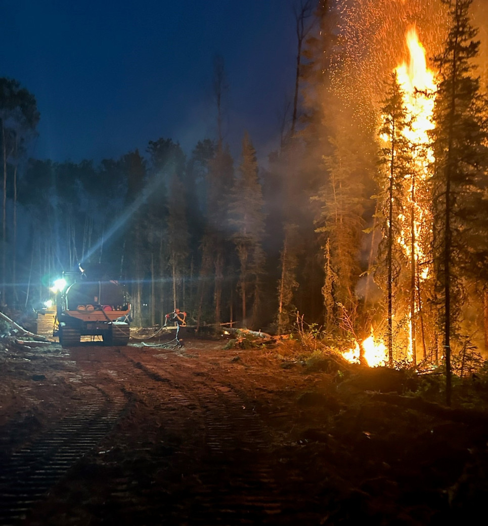 Fire crews are working around the clock to suppress HWF036 (June 1), which is between the towns of Rainbow Lake and High Level, and south of the community of Chateh.
Heavy equipment operators continue to build containment line east of the Chateh turnoff, along the northeastern fire perimeter, near the Sousa Creek, and ground crews with helicopter support continue to work along the established containment lines. Air tanker support is available, when required and when conditions are suitable.
Fire crews will continue their efforts day and night. Some additional resources have arrived, including an incident management team that is being established to oversee planning, operations and logistical support for fire crews, aircraft and heavy equipment operators working to suppress this wildfire.
Structure protection (SP) has been deployed within the community with additional SP resources from the Town of Rainbow Lake. Power to the communities of Rainbow Lake and Chateh has not been impacted by this fire at this time. ATCO crews continue to work on repairing damaged powerline infrastructure within the fire. Telus has completed repair work on communication infrastructure, which had been damaged, to reestablish communications for the Town of Rainbow Lake.
Travellers on Highway 58 should expect delays or intermittent closures (please check 511 for updates). The cause of this wildfire remains under investigation.
HWF037 west of TCFN South
This wildfire, which is out of control within the Buffalo Head Hills, is currently approximately 33 kilometers west of the community of Tall Cree First Nation (TCFN) South and an estimated 940 ha.
Heavy equipment has been deployed and is working its way in to action this fire directly. Additional assessments were conducted today as the heavy equipment group moves into position. Aircraft (skimmers) were able to conduct water drops this afternoon into the early evening. There is currently no threat to communities from this wildfire and its cause remains under investigation.
HWF040 east of La Crete Ferry
This wildfire, which is east of Highway 35 (approximately 22 km east of the La Crete/Tompkins Ferry), and just immediately south of Highway 697, remains an estimated 395 ha. Fire crews with helicopter support worked today to strengthen containment lines around the fire perimeter.
Structure protection is in place for all at-risk residences adjacent to the fire perimeter, which have been evacuated. The La Crete and Fort Vermilion fire departments will conduct patrols throughout the night.
Travellers on Highway 697 should expect delays or intermittent closures (please check 511 for updates). The cause of this wildfire remains under investigation.
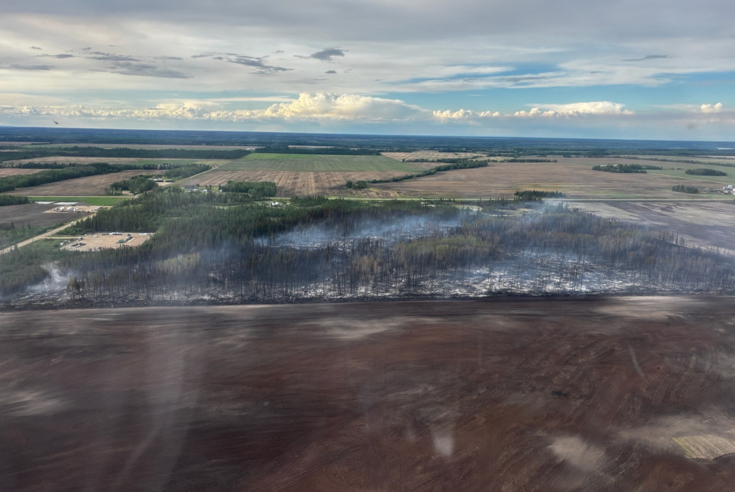 An aerial view of HWF040 — facing north — just south of Highway 697 (June 1).
Smoke from wildfire on the Alberta-B.C. border
Residents and others on the western side of the HLFA may see smoke from a wildfire (HBZ001) currently burning along the provincial border. The HLFA Fire Centre is in regular contact with its B.C. counterpart to monitor this wildfire. The Government of Canada also monitors smoke conditions across the country.
In 2025, there have been 43 wildfires in the HLFA to date, burning more than 26,000 ha.
To view wildfires on a map and for live updates, download the Alberta Wildfire App or visit the Alberta Wildfire Dashboard. Learn more about wildfire status definitions used in Alberta.
Fire ban
A fire ban is now in effect throughout the entire High Level Forest Area. Under this ban, all outdoor wood fires are prohibited and existing fire permits are suspended.
Prohibited:
- All outdoor wood fires, including wood campfires on public and private land, designated firepits and backyard firepits
- Barbecue charcoal briquettes
- Fireworks and exploding targets
Allowed:
- Propane fire pits and natural gas-powered appliances
- Indoor wood fires
- Open flame oil devices
The fire ban will remain in place until conditions improve.
Visit Alberta Fire Bans to see the boundaries of the fire ban implemented on May 29, 2025.
Lightning-caused wildfires
Lightning-caused wildfires are a common natural occurrence in Alberta, accounting for approximately 40% of the wildfires that occur each year. These wildfires often start in remote areas when lightning strikes dry vegetation, such as grass and trees, which can facilitate a quick start. Since these starts are often located far from roads or communities, they can easily go unnoticed.
Alberta Wildfire closely monitors lightning activity using resources such as aerial surveillance and fire lookout observers to detect and respond to these wildfires as quickly as possible. Many fire detections are also reported by the public.
As an example, several of the very recent wildfires starts detected in the Slave Lake Forest Area have been determined to have been caused by lightning.
All forest areas have firefighters and equipment ready to respond. Please call 310-FIRE if you see smoke or flames and suspect it's a wildfire. Learn more about how to report a wildfire.
Contact info
Mark Giles
780-285-4490
[email protected]
Published on June 1, 2025 8:36 pm