Aerial photographs
Aerial photographs are images of a portion of the earth's surface taken with a camera mounted in a fixed-wing aircraft.
The amount of area covered by a photograph depends on its scale, as the size of the photograph is constant. Individual photographs cover relatively small areas, ranging from 1.6 km x 1.6 km (1 mi. x 1 mi.) for very large scale photography (1:5 000), to 15 km x 15 km (9 mi. x 9 mi.) for small scale photography (1:60 000).
Explaining photograph scale
The scale of a photograph, like that of a map, is the ratio of distance on the photograph to the corresponding distance on the ground.
So, for example, if the scale of a photograph is 1:30 000, this simply means that one unit of any measure (inches, cm, etc.) represents 30,000 units of the same measure on the ground.
All areas of the province are available at either medium or small scales, while large-scale photographs are available for limited areas.
| Scale | Metric (1cm =) | Imperial (1 inch = approx.) |
|---|---|---|
| 1:15 000 | 0.15 km | approximately 1/4 mi. |
| 1:20 000 | 0.20 km | approximately 1/3 mi. |
| 1:30 000 | 0.30 km | approximately 1/2 mi. |
| 1:40 000 | 0.40 km | approximately 2/3 mi. |
| 1:50 000 | 0.50 km | approximately 3/4 mi. |
| 1:60 000 | 0.60 km | approximately 1 mi. |
Stereo coverage

Aerial photography is flown so each frame overlaps the previous frame by at least 60%. This overlapping area, although of the same portion of ground, has been photographed from 2 different angles, providing 2 different perspectives of that portion of ground. When adjacent photos are viewed through a stereoscope, the difference in perspective allows the viewer to see the image in 3 dimensions, or stereo. Generally, stereo pairs are purchased by engineering and resource professionals for mapping and interpretive purposes.
Legal land descriptions
Legal land descriptions are determined from the Alberta Township System (ATS). A legal land description of a parcel of land can be located through either of the following services:
- GeoDiscover Alberta – select the Alberta Township System layer for display
- Aerial Photographic Record System (APRS) – select the Alberta Township System layer for display
Any parcel of land in Alberta can be located by its legal land description. Legal land descriptions are based on the Dominion Land Survey. The ATS grid is part of the Dominion Land Survey which divides the province into equal sections of land.
Meridians
The most important north-south lines are of survey are meridians of longitude. In Alberta, land is designated as being west of the 4th, 5th, or 6th Meridians. The 4th Meridian is 110° W, and subsequent meridian occur every 4°W, making the 5th 114°W, and the 6th 118°W.
Ranges
Between meridians are six-mile-wide columns called ranges. Ranges are numbered consecutively from east to west starting at Range 1 west of each meridian.
Townships
Townships are six-mile-wide rows that intersect ranges and are numbered consecutively from Township 1 at the Montana border to Township 126 at the Northwest Territories border. The term township also describes the six-by-six mile square formed by the intersection of ranges and townships.
Sections, quarters and legal subdivisions
Townships are divided into 36 sections, each section measuring one-by-one mile. Sections can then be divided into quarters (NE, NW, SE, SW), or into 16 legal subdivisions (LSD), as indicated.
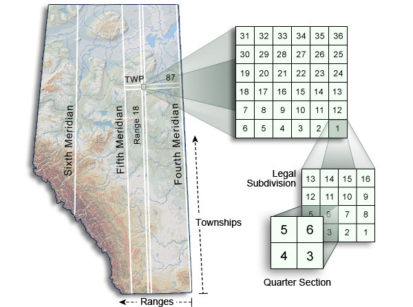
The legal description of the section highlighted in the diagram above would be written as:
SW-01-087-18-W4
Qtr-SecTwp-Rge-Mer
Contact
Note that the Air Photo Library is open by appointment only. For general queries, product orders or appointment bookings, contact us:
Phone: 780-427-3520
Toll free: 310-0000 before the phone number (in Alberta)
Email: [email protected]
Address:
Air Photo Library
2nd Floor East, Muriel Stanley Venne Provincial Centre
12360 142 Street NW
Edmonton, Alberta T5L 2H1