The wildfire danger is very high across the Slave Lake Forest Area due to hot, dry and windy conditions.
Under these conditions, combined with a chance of thunderstorms and lightning this afternoon, there is an increased risk of wildfires starting and spreading quickly.
Firefighters urge everyone to do their part to prevent wildfires. By preventing human-caused wildfires, you help keep firefighters available to respond to wildfires caused by lightning. Please be cautious with campfires, off-highway vehicles and any activity that could spark a fire.
Current wildfire situation
With a high chance of lightning, fire lookout observers are watching for smoke and firefighters supported by helicopters and airtankers are ready to respond to any new wildfires that may start.
Firefighters in a helicopter and airtankers responded to 1 new wildfire last night in the Peavine Metis Settlement. SWF130 is 0.7 hectares and is being held. Firefighters with a helicopter are being deployed to extinguish this wildfire.
Currently there are 14 active wildfires in the Slave Lake Forest Area.
To view wildfires on a map visit the Alberta Wildfire Status Dashboard.
Since January 1, 2025, there have been 130 wildfires in the Slave Lake Forest Area, resulting in a total burned area of 391, 657 hectares (ha).
Red Earth East Complex
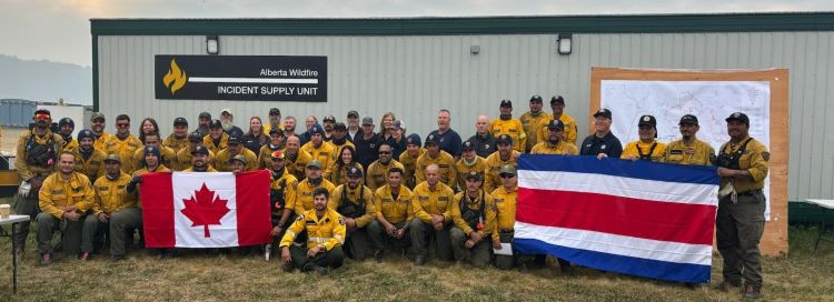 Firefighters on the Red Earth East Complex wish everyone a Happy Canada Day! July 1, 2025
The Red Earth East Complex includes 10 wildfires that are located east of Highway 88: SWF085, SWF089, SWF091, SWF092, SWF094, SWF095, SWF099, SWF100, SWF110 and SWF115.
View the latest map of the Red Earth East complex.
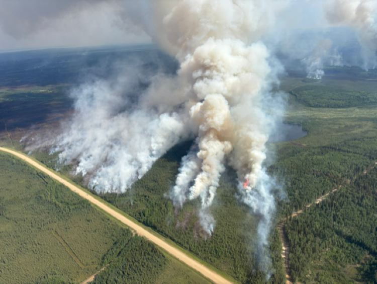
With hot, dry and windy conditions today, increased fire activity is expected and smoke will be visible from the wildfires in the complex. Firefighters supported by helicopters with buckets are deployed to active areas and airtankers will be requested if required.
Due to the wildfire activity and the shift in wind, smoky conditions are present in the Red Earth Creek area. Visit www.firesmoke.ca to see where the smoke is coming from. Anyone with health concerns should visit Alberta Health Services or call 811 for health advice from Alberta Health Link.
SWF085, which impacted the community of Chipewyan Lake, is 138,058 ha in size and is classified as out of control. The wildfire threat to the community of Chipewyan Lake remains minimal. Firefighters in a helicopter continue to monitor the wildfire and have reported little to no fire activity observed over the past several days.
SWF089, located approximately 5.5 km east of Peerless Lakes, is 12,958 ha in size and is classified as out of control. Firefighters are working to extinguish the identified hot spots on the south side of the wildfire.
SWF092, located approximately 7 km southeast of Red Earth Creek and 8.5 km west of Trout Lake, is 81,329 ha in size and is classified as out of control. Warm and dry conditions are causing increased fire activity on the south side of the wildfire, smoke may be visible from Highway 88. Helicopters equipped with buckets are actively working to cool hot spots in this area. Over night, an infrared scan was conducted on the east and south side of the wildfire. This scan identifies areas of fire burning beneath the ground and will help focus firefighting efforts. On the northeast side, firefighters are focused on extinguishing remaining hot spots to help prevent any potential spread toward the community of Trout Lake. Firefighters are extinguishing hot spots along the containment lines on the northwest side closest to Red Earth Creek.
SWF095, located approximately 5 km from Peerless Lake and 7 km from Trout Lake is 1,308 ha in size and is classified as being held. WUI crews are testing equipment and conducting emergency drills to stay prepared and keep their skills sharp. Fire activity remains low and is mostly smoldering. Firefighters in helicopters continue to monitor the wildfire.
 Yesterday, firefighters conducted a controlled burn on SWF100 on south side of Highway 686. June 30, 2025
SWF100, located approximately 5 km west of Peerless Lake, is 18,289 ha in size and is classified as out of control. The controlled burns have been completed on the west side of the wildfire, south of Highway 686. Firefighters are being deployed to extinguishing hot spots in this area.
Evacuation order
Firefighters are working extremely hard, but at this time, it is not safe for the residents of the following communities to return home. Multiple hot spots remain active, firefighting operations are ongoing and the wildfire perimeters have not yet been fully secured.
Wildland Urban Interface (WUI) crews continue to test pumps and sprinkler setups daily in the communities of Peerless Lake and Trout Lake.
An evacuation order remains in effect for the communities of Chipewyan Lake, and Trout Lake and Peerless Lake.
Evacuation alert
A 2 hour evacuation alert remains in effect for the communities of Red Earth Creek and Loon Lake.
For information about the wildfires in the Red Earth East Wildfire Complex, please email [email protected]
Blue Sky and Edith Lake wildfires (SWF088 and SWF076)
The Blue Sky Wildfire (SWF088), located 22 km north of Marten Beach is 13,684 hectares in size and is classified as under control. Firefighters, supported by heavy equipment and helicopters, continue to extinguish hot spots on the northwest and south side of the wildfire which were identified by the recent infrared scan.
View the latest map of the Blue Sky wildfire.
The Edith Lake wildfire (SWF076), located approximately 8 km north of Swan Hills, is 16,852 hectares in size and is classified as under control. Firefighters are monitoring this wildfire by helicopter and heavy equipment continues to reclaim the containment lines.
View the latest map of the Edith Lake wildfire.
For more information these wildfires, contact Leah Lovequist at 780-849-0945 or [email protected]
Fire permits are required
From now until October 31, fire permits are required for any burning, except campfires, in the Forest Protection Area of Alberta. Fire permits are free and are now available online. Visit Get a fire permit for information on how to make a request online.
Fire permits are also still available, by request, from your local forest area office.
- Wabasca 780-891-3860
- Slave Lake 780-849-7377
- High Prairie 780-523-6619
Celebrating with fireworks for Canada Day
The use of fireworks within the Forest Protection Area (FPA) is prohibited without written permission from a Forest Officer. Written permission is required year-round. To obtain written permission to shoot, discharge, detonate or ignite fireworks within the FPA call your local forest area office.
Choose a safe campfire site
When visiting campgrounds or recreational areas, use the designated stoves, fire rings or fire pits. These are designed to keep fires from spreading and are the best choice for a safe campfire. When outside of a campground, use sites that are clear of dry grass and vegetation. Clear the site down to bare mineral soil, place rocks in a ring, keep it sheltered from wind and always have water nearby to extinguish your campfire.
Never leave a campfire unattended. When you're done, always soak it, stir it and soak it again until the ashes are cool to the touch.
When riding your off-highway vehicle
Off-highway vehicles (OHVs) have exhaust systems that get hotter than 200°C. At these temperatures, built-up materials (such as grass, muskeg, moss or other debris) can heat up, smoulder and ignite. These can fall to the ground as you are riding, starting a wildfire.
To help prevent wildfires when riding your OHV, stop frequently to remove any build- up of debris on your machine's muffler and always carry firefighting equipment such as a small shovel, collapsible pail or fire extinguisher.
Published on July 1, 2025 10:55 am