Fire danger across most of the Slave Lake Forest Area is moderate to high. North of Red Earth, it is high to very high, while south of Slave Lake, which received more rain, remains low.
Wildfire situation
There are 13 active wildfires in the Slave Lake Forest Area, 7 are out of control and 6 are under control.
Since January 1, 2025 there have been 171 wildfires reported in the Slave Lake Forest Area, burning a total of 378,642 ha.
See the Alberta Wildfire Status Dashboard for up-to-date information on wildfire locations, status, size, statistics and more.
SWF167, located approximately 70 km north of Red Earth Creek, is estimated to be 40 hectares (ha) and is classified as out of control. This wildfire occurred on August 5 and was caused by lightning. Firefighters with helicopters continue to make good progress fighting this wildfire. The wildfire does not pose a threat to highway 88.
SWF171, located in Prairie Echo approximately 8.5 km northeast of Heart River, is estimated to be 30 hectares (ha) and is now classified as under control. Air tankers, firefighters and helicopters responded quickly this afternoon. At this time the wildfire does not pose a threat to nearby communities or highway 679.
Red Earth East Complex
The Red Earth East Complex includes 8 active wildfires that are located east of Highway 88.
Map of the Red Earth East Complex
- Out of control: SWF085, SWF089, SWF092, SWF094, SWF100 and SWF115
- Under control: SWF095 and SWF099
An evacuation order remains in effect for Chipewyan Lake. The wildfire threat to the community remains minimal.
Cool, cloudy conditions kept fire activity low yesterday morning, but fire activity picked up in the northeast after skies cleared in the afternoon. Today’s forecasted warmer temperatures, gustier winds and limited cloud cover could cause an increase in fire behaviour in active areas of the wildfires.
Firefighters, supported by helicopters and heavy equipment, continue working to strengthen containment lines and extinguish hotspots. These wildfires are large and will take time to fully extinguish. Smoke may be visible at times.
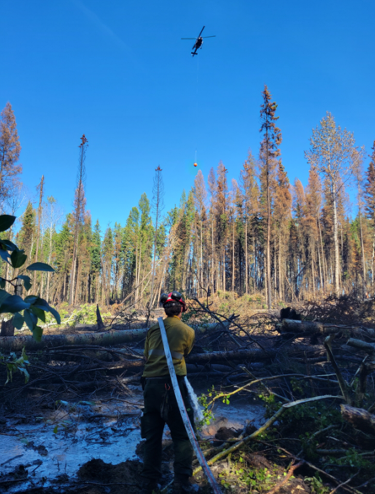 Firefighter applies foam on SWF092 as a helicopter drops water on hotspots. Aug. 8, 2025.
- SWF085, which impacted the community of Chipewyan Lake, is 137,298 ha in size. Firefighters in a helicopter continue to monitor the wildfire for activity.
- SWF089, located approximately 5.5 km east of Peerless Lake, is 12,382 ha in size.
- SWF092, located about 7 km southeast of Red Earth Creek and 8.5 km west of Trout Lake, is 82,720 ha.
- SWF094, located about 31 km northwest of Chipewyan Lake, is 73,675 ha.
- SWF100, located approximately 5 km west of Peerless Lake, is 18,005 ha in size.
For information about the wildfires in the Red Earth East Wildfire Complex, please email [email protected].
Give firefighters space to work
There are active wildfire operations happening in and around communities. For your safety and ours, please avoid these areas and give firefighters the space they need to work safely.
The Red Earth Creek Airport is currently being used as a staging area for personnel, helicopters, and equipment. Helicopters and heavy equipment are operating regularly, and unauthorized access creates a serious risk.
Get your free fire permit
From March 1 to October 31, a fire permit is required for any burning in the Forest Protection Area, except for a campfire. Fire permits ensure safe burning practices are being followed and allow firefighters to know where burning is approved.
Fire permits are free and can be requested online. You may also request your fire permit by calling your local forestry office.
- Slave Lake 780-849-7377
- Wabasca 780-891-3860
- High Prairie 780-523-6619
Contact info
Dan Troke
780-843-5772
[email protected]
Published on August 9, 2025 2:04 pm