About the indicator
Alberta’s protected and conserved areas network is vital to conserve habitat and maintain provincial biodiversity for present and future generations. Protected and conserved areas provide many benefits to Albertans, including:
- Maintaining ecosystem health, including plant and animal life
- Safeguarding ecosystem services that enhance water quality and quantity, air quality and carbon storage
- Supporting the health and well-being of Albertans
- Increasing climate resilience and shielding against some extreme weather events
- Economic benefits from nature-based tourism, particularly to local communities
- Supporting environmental science, research and education initiatives
Protected and conserved areas provide the foundation for well-developed conservation strategies in most jurisdictions across the globe and tracking their abundance and distribution is a widely used approach to assess progress toward meeting conservation goals.
The Canadian Protected and Conserved Areas Database (CPCAD) tracks progress across all provinces and territories in Canada (ECCC 2025) in accordance with globally recognized definitions.
Protected and conserved area facts
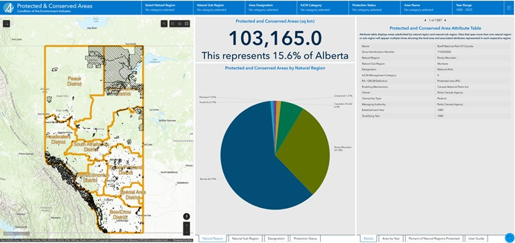
- Alberta reported 15.6% of its land base as protected and conserved into CPCAD in 2024, ranking fifth among Canadian provinces and territories (ECCC 2025; see Protected and conserved area dashboard below for full details).
- Canada reported 13.8% of the country’s terrestrial area as protected and conserved in 2024.
- Globally, 17.1% of the earth’s terrestrial habitat (including freshwater habitat), falls within protected areas (ECCC 2023).
Alberta is home to one of the world’s largest contiguous (connected) boreal protected areas, located in the northeastern part of the province. This network of protected areas connects Wood Buffalo National Park (36,186 km2) with several wildland provincial parks, including Kazan and Caribou Mountains Wildland Provincial Parks (6,593 km2 and 5,922 km2 , respectively) and other types of protected areas. Alberta’s Rocky Mountain region is also highly protected (30,107 km2) providing an important wildlife corridor.
Protected and conserved areas dashboard
Explore Alberta’s protected and conserved areas through our spatially linked dashboard. Search for a specific site or explore the interactive map to see how these areas are distributed across the province, learn about a site's status and representation across natural regions, and much more.
Methods and data limitations
This indicator uses information from the Canadian Protected and Conserved Areas Database (CPCAD) which contains spatial and attribute data on marine and terrestrial protected areas and other conserved areas in Canada. It is updated annually by:
- federal, provincial and territorial governments
- other reporting authorities such as Indigenous governments and land trusts
This indicator is based on the 2025 CPCAD data which is applicable to December 2024 (ECCC 2025).
Summary of key results
Last updated: June 2025 | Next update: 2026
- 15.6% of Alberta was designated as protected and conserved in 2024.
- Most protected areas (by area) were established in the province prior to 1930 (predominantly National Parks) or after 1995. A notable exception is the creation of Willmore Wilderness Park designated in 1959.
- The Canadian Shield and Rocky Mountain natural regions have the highest percentage of land protected and conserved in the province at 73% and 61%, respectively.
- The Grassland, Foothills and Parkland natural regions have the lowest percentage of land protected and conserved at less than 2% of their total areas.
- Conserved areas in Alberta were first reported to CPCAD in 2024; however, many of these sites have been effectively managed to conserve biodiversity for decades.
Changes over time
Protected and conserved area designation in Alberta began in 1885 with the establishment of Canada’s first national park, Banff. Designation of other national parks including Waterton, Jasper, Elk Island and Wood Buffalo National Park followed in subsequent decades and by 1930, these sites encompassed over 8% (53,860 km2) of the province’s land base.
Protection was further prioritized in the 1950’s and onwards with the introduction of provincial legislative tools (e.g., Provincial Parks Act, Willmore Wilderness Park Act, Wilderness Areas, Ecological Reserves, Natural Areas and Heritage Rangelands Act; Figure 1).
Figure 1. Protected and conserved areas in Alberta over time by jurisdiction
Source: Government of Alberta
Alberta’s provincial parks were originally established for the purpose of outdoor recreation until the mid-1950s. The designation of Dinosaur Provincial Park in 1955 marked a shift to establishing areas to conserve important natural and historical features. This sparked a new wave of protected area designations, including the establishment of Willmore Wilderness Park in 1959.
- Protected areas were further expanded in the late 1990s through the Special Places Initiative that sought to protect Alberta’s natural diversity, adding 20,000 km2 of protected area in the province.
- Establishment of land use planning frameworks including the Lower Athabasca and South Saskatchewan Regional Plans are responsible for a further increase in protected areas between 2014 and 2018, adding approximately 15,000 km2 and 1,300 km2, respectively.
- The designation of Kitaskino Nuwenëné Wildland Provincial Park (1,618 km2) under the Lower Athabasca Regional Plan in 2019 played a large role in growing Alberta’s protected areas network. This provincial park, combined with surrounding provincial and federal protected areas in northeastern Alberta, forms one of the largest contiguous boreal protected areas in the world at 71,000 km2.
- Most recently, Gipsy-Gordon Wildland Provincial Park was designated in 2025, adding over 1,500 km2 of new protected area. This park builds on the existing Gipsy Lake Wildland Provincial Park to create a contiguous protected area covering over 1,850 km2 in northeastern Alberta.
Today, Alberta is home to over 230 provincially designated protected areas that are reported to CPCAD, covering 46,678 km2. While over 100 of Alberta’s provincially designated protected areas are under 5 km2, they still serve an important role in protecting Alberta’s diverse landscapes and ecosystems.
- Wildland Provincial Parks (43 parks) comprise over 75% of Alberta’s provincially designated protected areas and 36% of Alberta’s total protected and conserved areas.
Federal and provincial protected and conserved areas account for 99% of reported protected and conserved areas (Figure 2; Figure 3). Reported private protected and conserved areas make up 0.9%, municipal protected areas and Indigenous protected areas less than 0.01%. Conserved areas have existed in Alberta since at least the 1950s; however, they were first reported in the CPCAD in 2024.
Figure 2. Protected and conserved areas in Alberta by jurisdiction
Use the legend to toggle jurisdictions on or off in the pie chart. Colours represent the protected and conserved areas by jurisdiction, and the labels show the proportion of each designation type within that jurisdiction. Municipal and Indigenous areas make up a small proportion of Alberta’s total reported protected and conserved areas and will only become visible once filtered in the pie chart.
Source: Government of Alberta
Figure 3. Map | Protected and Conserved Areas in Alberta over time (1930-2024)
Representation across the landscape
Alberta’s natural landscapes are classified into natural regions and subregions based on their unique mix of vegetation, soils, and landform features (Natural Regions Committee 2006). Six natural regions are recognized in Alberta, including: Boreal Forest, Canadian Shield, Foothills, Grassland, Parkland and Rocky Mountain.
Protected and conserved areas are not evenly distributed across Alberta’s natural regions (Figure 4). The establishment of several large National Parks, Willmore Wilderness Park and Wildland Provincial Parks have resulted in relatively high percentages of protected and conserved areas in the following natural regions:
- Canadian Shield (73%)
- Rocky Mountain (61%)
- Boreal Forest (16%)
Occurrence of protected and conserved areas is lower in natural regions that have generally fewer opportunities for establishing large-scale protection within private lands, coupled with widespread impacts from agriculture, industry and high levels of urbanization and development. These include the:
- Foothills (1.2%)
- Grassland (1.4%)
- Parkland (1.7%)
The Parkland natural region is only found in North America, and Alberta contains one of the largest remaining areas of Parkland globally. This natural region is one of the least protected in the province yet faces some of the greatest threats of population growth near the cities of Calgary, Edmonton and Red Deer.
Private land conservation efforts are especially important in the Foothills, Grassland and Parkland natural regions, including land trust properties that are reported as protected or conserved areas. It is important to note that reporting protected and conserved areas on private land is voluntary. As such, there are many additional sites that could be considered privately conserved areas in Alberta that are not currently reported to CPCAD.
Figure 4. Percent of natural regions currently designated as protected and conserved areas in Alberta
Source: Government of Alberta
Management effectiveness
Once established, protected and conserved areas must be effectively managed to successfully achieve their intended conservation outcomes over the long term. Alberta Forestry and Parks has completed management effectiveness assessments for several provincial protected areas using evaluation tools adapted to the Alberta context and aligned with a global standard framework (Hockings et al. 2006). These evaluations focus on assessing the extent to which provincial protected areas are:
- maintaining natural and social values
- achieving their specific goals and objectives, including biodiversity and ecosystem integrity
- implementing adaptive management actions including monitoring, to address risks, threats and challenges.
It is important to note that area-based protection does not safeguard an area from all potential environmental stressors. For example, 86% of the Alpine subregion in Alberta’s Rocky Mountain natural region is protected; however, the protected status of this subregion will not negate potential impacts from a warming climate.
Recap | Alberta's protected and conserved areas
Established protected and conserved areas in Alberta cover 15.6% of the province.
The top 3 designations of protected and conserved areas in Alberta, by area, are (Figure 2):
- National Parks (5 sites) represent 54% (53,860 km2) of our protected areas.
- Wildland Provincial Parks (43 sites) represent 36% (36,436 km2) of our protected areas.
- Willmore Wilderness Park represents 5% (4,602 km2) of our protected areas.
Provincially managed protected areas in Alberta increased by 75% in the last decade; an increase stemming primarily from approved land use plans.