The fire danger remains extreme. Forest vegetation is extremely dry and poses a very serious fire risk. Fast-spreading, high-intensity fires are possible, which can make firefighting challenging.
Wildfire situation
Sousa Creek Wildfire (HWF036)
The Sousa Creek Wildfire is located between the towns of Rainbow Lake and High Level, near the Chateh turnoff, and along both sides of Highway 58. This wildfire is currently out of control and estimated to cover 45,239 hectares (ha). The cause of this wildfire is under investigation.
Growth, proximity to communities
There has been no observable growth or new hot spots beyond the current perimeter over the past 24 hours. Firefighters with heavy equipment continue to strengthen the containment line along the north and northeast sides (in proximity to the community of Chateh), while fire crews with bucketing helicopters continue their efforts on the west and southwest sides to prevent additional growth in these areas.
While there has been a relatively small increase in the recorded size of HWF036 since yesterday, this is due to a recalculation and reflects a more accurate assessment of the overall size of this wildfire. The perimeter remains essentially the same today and the fire remains approximately the same distance from the communities noted below. HWF036 remains approximately:
- 5.2 km from the southern edge of the community (reserve area) of Chateh;
- 55 km from the southeast edge of the community (reserve area) of Meander River;
- 71 km from the western edge of the Town of High Level; and
- 27 km from the eastern edge of the Town of Rainbow Lake.
"Edge" refers to the boundary or corporate limits (as applicable) of each community.
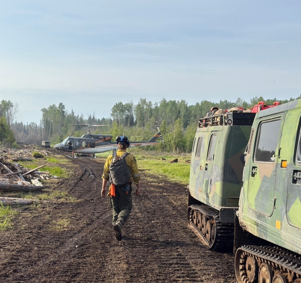 A medium helicopter and tracked vehicles (Hagglund) move firefighters into location on HWF036 (June 15)
Airtankers are being used, as needed, and night-vision-equipped helicopters are also being employed on HWF036, when available and when conditions (primarily visibility) permit, to assist with overnight operations.
Alberta Wildfire continues to coordinate closely with Chateh community leaders and their emergency management team. Power to the Town of Rainbow Lake and Chateh is not currently impacted. ATCO crews continue working to repair damaged powerline infrastructure.
Posted speed and highway closures
Please respect the 50 km/h signs for everyone’s safety. Expect delays or intermittent closures on Highway 58. Visit Alberta 511 for updates.
Smoke or fog from HWF040
HWF040, which is about 22 km east of the La Crete (Tompkins) Ferry and about 395 ha in size, remains under control. There is, however, an area of peat soil within the interior of this wildfire. Given the nature of peat and the likelihood of an inversion — a layer of warmer air covering a cooler one, reversing the normal temperature gradient where air cools with increasing altitude — residents and others in the area may see a fog or smoke in the vicinity. This is expected and does not indicate an increase in overall fire activity.
Smoke from wildfires on the Alberta-B.C. border
Residents and others on the western side of the forest area may see smoke from three wildfires (HBZ001, HBZ002 and HBZ003) currently burning along the provincial border. The High Level Fire Centre is in regular contact with its B.C. counterpart to monitor these wildfires. Visit Fire Smoke Canada to see where smoke is coming from. If you have smoke-related health concerns, call 811 or visit Alberta Health.
Wildfire statistics
Since January 1, there have been 53 wildfires in the High Level Forest Area, burning a total of approximately 46,797 ha. To view wildfires on a map and for live updates, download the Alberta Wildfire App or visit the Alberta Wildfire Dashboard. Learn more about wildfire status definitions used in Alberta.
Fire ban
A fire ban remains in effect for the High Level Forest Area. Under this ban, all outdoor wood fires are prohibited, and existing fire permits are suspended.
Prohibited:
- All outdoor wood fires, including wood campfires on public and private land, designated firepits and backyard firepits
- Barbecue charcoal briquettes
- Fireworks and exploding targets
Allowed:
- Propane fire pits and natural gas-powered appliances
- Indoor wood fires
- Open flame oil devices
The fire ban will remain in effect until conditions improve. Visit Alberta Fire Bans for more information and to see the boundaries. See the fire ban fact sheet for more information.
Contact info
Mark Giles
780-285-4490
[email protected]
Published on June 16, 2025 1:22 pm