The fire danger remains extreme. The forest vegetation is extremely dry and pose a very serious fire risk. Fast-spreading, high-intensity fires are likely, which will make firefighting challenging.
We urge residents, members of the public and industry to use extreme caution until conditions improve. Plan any activities that could create a spark, hot exhaust or friction late in the evening or early in the morning. Keep watch of your surroundings and carry sufficient firefighting equipment and water if you are working outdoors.
Wildfire situation
Since January 1, there have been 48 wildfires in the High Level Forest Area burning a total of 42,797 hectares (ha). To view wildfires on a map and for live updates, download the Alberta Wildfire App or visit the Alberta Wildfire Dashboard. Learn more about wildfire status definitions used in Alberta.
Sousa Creek Wildfire (HWF036)
The Sousa Creek Wildfire is located between Rainbow Lake and High Level, near the Chateh turnoff, and along both sides of Highway 58. This wildfire, which is out of control, is estimated to be 41,242 ha. The cause of this wildfire remains under investigation.
The wildfire is located approximately 5.3 km from the southern edge of the community (reserve area) of Chateh, 55 km from the southeast edge of the community (reserve area) of Meander River, 71 km from the western edge of the Town of High Level and 27 km from the eastern edge of the Town of Rainbow Lake. A wildfire perimeter map is available.
Today, a high of 24C and relative humidity of 30% is expected. Winds from the southeast are expected to shift, coming from the southwest 15-20 gusting to 35 km/h later this afternoon. Smoke will be seen again today on HWF036.
Firefighters, supported by helicopters and heavy equipment, continue to work along the north and northeastern perimeter, near Sousa Creek. Heavy equipment was able to access the northeast side of the wildfire, they were met with challenges due to wet soft soil. Heavy equipment continues to build containment lines along the northwestern perimeter, south of Highway 58.
Airtankers supported firefighters yesterday on the northwest side of the wildfire. Firefighters will assess the conditions and request airtanker assistance if required.
Alberta Wildfire continues to work closely with the Chateh Fire Department to coordinate and maintain structure protection in and around the community. Power to the Town of Rainbow Lake and Chateh is not currently impacted. ATCO crews continue to work on repairing damaged powerline infrastructure within the fire.
Posted speed signage and highway closures
Firefighters are asking members of the public to slow down near work areas. Please respect the 50 km/h signs for everyone’s safety.
Expect delays or intermittent closures on Highway 58. Visit Alberta 511 for updates.
HWF037
This wildfire is within the Buffalo Head Hills, about 33 km west of the community of Tall Cree First Nation South. It is out of control at about 1,060 ha.
Firefighters supported by helicopters continue making good progress building containment lines, with a focus on the south side. This will be followed by work on the eastern side, along a corridor between two previously burned areas that is stalling growth to the east-southeast. There is currently no threat to communities, and its cause is under investigation.
HWF040
This wildfire, which is east of the La Crete Ferry and just south of Highway 697, is being held at about 395 ha. Firefighters supported with helicopters, water trucks and a nodwell continue to action this fire.
Travellers on Highway 697 should expect delays (please check 511 for updates). The cause of this wildfire remains under investigation.
Smoke from wildfires on the Alberta-B.C. border
Residents and others on the western side of the forest area may see smoke from two wildfires (HBZ001 and HBZ002) currently burning along the provincial border. The High Level Fire Centre is in regular contact with its B.C. counterpart to monitor these wildfires. The Government of Canada also monitors smoke conditions across the country.
Safety near burnt areas
We urge residents and members of the public to use extra caution near burnt areas. There are many hazards that may not be visible, like deep burning ash pits and falling trees. Burnt trees are a serious hazard, and trees that may look healthy that have green needles or leaves could have burnt out roots under the ground and fall unexpectedly. Keep in mind that trees and powerlines could also fall on the road and block your vehicle. Do not approach powerlines as they could be energized.
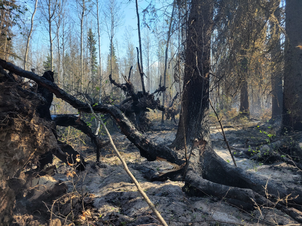 Wildfire will burn around roots, compromising the strength of the tree. Use caution near burnt areas (HWF036 on June 7, 2025)
Illegal use of drones near wildfires
Flying a drone near or over a wildfire endangers our pilots and forces us to ground aircraft, causing delays in firefighting operations. You could face a hefty fine for putting aircraft and people at risk. Please give our firefighters the space they need to do their jobs safely.
Fire ban
A fire ban is in effect for the entire Forest Protection Area in Alberta. Under this ban, all outdoor wood fires are prohibited and existing fire permits are suspended.
Prohibited:
- All outdoor wood fires, including wood campfires on public and private land, designated firepits and backyard firepits
- Barbecue charcoal briquettes
- Fireworks and exploding targets
Allowed:
- Propane fire pits and natural gas-powered appliances
- Indoor wood fires
- Open flame oil devices
The fire ban will remain in effect until conditions improve. Visit Alberta Fire Bans for more information and to see the boundaries. See the fire ban fact sheet for more information.
Contact info
Caroline Charbonneau
780-740-1341
[email protected]
Published on June 8, 2025 1:47 pm