The fire danger in the Grande Prairie Forest Area remains extreme. Forest vegetation is extremely dry and can easily ignite, and strong winds can quickly drive fires to spread rapidly and unpredictably. These conditions can result in fast-moving, high-intensity wildfires that are difficult to control.
Wildfire situation
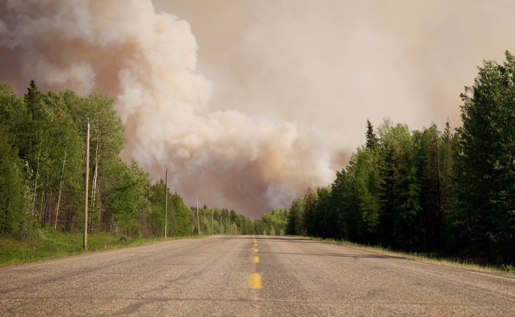
GWF028 - Strong winds fuel fire behaviour
Yesterday, strong winds and ongoing dry conditions caused increased activity in wildfire GWF028, resulting in extreme fire behaviour. Smoke has limited visibility this morning, so an updated perimeter and size assessment is still underway. Currently, the wildfire is estimated to be within 5 km northwest of Moonshine Lake Provincial Park. Alberta Wildfire is responding with firefighters, heavy equipment, and air support.
Saddle Hills County has activated its emergency coordination centre and is responding with resources from the Blueberry and Happy Valley fire stations. Structure protection with sprinklers is planned for today, and overnight patrols were conducted to monitor fire activity.
Moonshine Lake Provincial Park has been evacuated and remains closed.
For more details, including evacuee information, visit the Saddle Hills County webpage or Facebook page.
Saddle Hills County evacuation order and alert
Saddle Hills County has expanded its evacuation order while the evacuation alert remains the same. For everyone's safety, it's critical to follow all evacuation instructions, as wildfire conditions can change rapidly. Stay informed and be prepared to act immediately.
See Alberta Emergency Alert for evacuation zone information and further details.
Road reports
Highway 725 is currently open but could close if conditions worsen. Please visit 511 Alberta for the most up to date information.
GWF040 - New wildfire south of Grande Prairie
Alberta Wildfire is actively responding to wildfire GWF040, located approximately 81 km south of Grande Prairie and 19 km east of Highway 40. This wildfire was detected yesterday, and is estimated at 325 hectares in size, with firefighting crews, heavy equipment, and aircraft deployed to the area.
A section of the Forestry Trunk Road has been closed. For the latest updates on local road closures (non-highway roads) in this wildfire area, check the M.D. of Greenview’s webpage and Facebook page.
M.D. of Greenview issues evacuation order
Today at 11:03 am, the M.D of Greenview issued an evacuation order because of this wildfire. For everyone's safety, it's critical to follow all evacuation instructions, as wildfire conditions can change rapidly. Stay informed and be prepared to act immediately.
See Alberta Emergency Alert for evacuation zone information and further details.
Kiskatinaw River wildfire (GBZ001)
Alberta Wildfire, BC Wildfire Service, and the County of Grande Prairie are working together to manage the Kiskatinaw River wildfire (GBZ001/G70422), which remains classified as out of control. The fire is estimated to be 21,679 hectares in size.
Today is expected to bring more moderate fire behaviour conditions. Temperatures this morning are around 4°C, humidity at 60%, and no wind—significantly more stable than the previous 4 to 5 days. While temperatures are expected to climb to 22°C this afternoon and humidity will dip to 18%, only light north-northeast winds are forecast, which will help limit fire behaviour. While fire activity could pick up again tomorrow as winds strengthen and humidity drops, today is expected to offer a temporary reprieve in fire behaviour.
Crews are preparing to do planned ignitions today to bring the fire to established control lines along the north side. These operations will be supported by both wildland firefighters and structure protection personnel.
Structure protection continues in Kelly Lake and the County of Grande Prairie. Firefighters are actively working on the northeast corner of the wildfire, using both firefighters and heavy equipment to build containment lines to slow the fire’s spread.
For more information on this wildfire and others in B.C., visit the BC Wildfire Service website.
 Kiskatinaw River wildfire on June 8. Photo: BC Wildfire Service.
County of Grande Prairie evacuation order and alert
The County of Grande Prairie has an evacuation order and an evacuation alert in effect. For your safety, it's critical to follow all evacuation instructions, as wildfire conditions can change rapidly. Stay informed and be prepared to act immediately.
- Alberta residents - for more details, visit the Alberta Emergency Alert website or download the app. Detailed updates are also available on the County of Grande Prairie website and Facebook page.
- British Columbia residents - visit the Peace River Regional District website or their Facebook page.
Grande Prairie Regional Emergency Partnership (GPREP) assisting evacuees
GPREP remains activated and is assisting evacuees living within the County of Grande Prairie. Updates can be found on their webpage and Facebook page.
Road reports
Highway 43 is currently open but could close if conditions worsen. Please visit 511 Alberta for the most up to date Alberta road reports, and DriveBC for British Columbia roads.
Grande Prairie Forest Area statistics
Since January 1, there have been 40 wildfires in the Grande Prairie Forest Area, burning a total of 642 hectares.
Learn more about active wildfires, their locations and stats on the interactive map on our wildfire status page.
Fire ban
A fire ban remains in effect for the Grande Prairie Forest Area. Under this ban, all outdoor wood fires are prohibited and existing fire permits are suspended.
Prohibited:
- All outdoor wood fires, including wood campfires on public and private land, designated firepits and backyard firepits
- Barbecue charcoal briquettes
- Fireworks and exploding targets
Allowed:
- Propane fire pits and natural gas-powered appliances
- Indoor wood fires
- Open flame oil devices
The fire ban will remain in place until conditions improve. For details and updates, visit Alberta Fire Bans.
Evacuation preparedness
Have an emergency plan in case you and your family need to evacuate. Individuals and families should be prepared to take care of themselves for at least 72 hours. Be sure to also plan for your pets and livestock in case of an evacuation.
- Evacuation alert: Issued when there is a potential threat. This gives residents time to prepare so they are ready to act quickly by packing essentials, collecting important documents, fueling vehicles, making arrangements for pets and livestock, etc.
- Evacuation order: Issued when there is an immediate risk to life or safety. Residents may be directed to leave the area immediately—there may be no time to gather belongings.
Wildfire smoke
Smoke may be visible and settling over our communities. Visit Fire Smoke Canada to see where the smoke is coming from.
If you have smoke-related health concerns, call 811 or visit the Alberta Health website.
Illegal use of drones near wildfires
Flying a drone near or over a wildfire endangers our pilots and forces us to ground aircraft, causing delays in firefighting operations. You could face a hefty fine for putting aircraft and people at risk. Please give our firefighters the space they need to do their jobs safely.
For more information visit Transport Canada.
Contact info
Kassey Zatko
780-538-5327
[email protected]
Published on June 10, 2025 12:57 pm