Notifications

Government mail service may be affected by the Canada Post labour disruption. Learn about how critical government mail will be handled.

Wildfire update

Grande Prairie Forest Area - July 17, 2025 - 4:30 pm

High wildfire danger

The wildfire danger is high in the Grande Prairie Forest Area. Recent warm temperatures and winds have dried out vegetation. Although some rain has fallen, it has only reached parts of the forest area and did not significantly reduce the overall wildfire risk.

If you're spending time or working outdoors, use extra caution, as these conditions can lead to fast-moving wildfires. 

Wildfire situation

For the most current information on active wildfires, including their locations and stats, visit our interactive wildfire map or download the AB Wildfire Status app.

GWF063 – Wildfire north of the Two Lakes Road is now being held

Alberta Wildfire continues to respond to GWF063 located approximately 50 km southwest of Grande Prairie and 1 km north of the Two Lakes Road. It is now classified as being held and estimated at 40 hectares in size. 

Firefighters, helicopters and heavy equipment continue working to contain the wildfire. Recent rain in the area has supported firefighting efforts. 

For the latest municipal updates, including information about the Two Lakes Road, please visit the M.D. of Greenview website.

An aerial view of a wildfire burn area showing a mix of scorched and green forest. A helicopter is mid-air with a water bucket suspended beneath it, while heavy equipment works on the ground near a cleared path through the burned trees. 
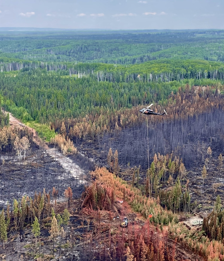
A helicopter carrying a water bucket flies over wildfire GWF063 as firefighting efforts continue. Photo: July 16.

GWF028 - The Hamelin Creek wildfire 

The Hamelin Creek wildfire, located near Moonshine Lake Provincial Park, remains classified as being held. It is estimated at 5,557 hectares in size. Firefighters, supported by heavy equipment and helicopters, continue to make steady progress by strengthening containment lines and extinguishing hot spots. Dry conditions in the area are adding to the challenge, as the wildfire is burning deep underground. The cause has been determined to be lightning.

We’ve received reports of individuals riding off-highway vehicles on containment lines where heavy equipment has pushed down trees. This is both illegal and dangerous—for your safety and for the safety of our firefighters. This remains an active wildfire area, with ongoing operations involving helicopters and heavy equipment. Burnt trees can fall without warning, even without wind. Please stay clear of all active wildfire areas.

For municipality-related updates, including their public safety notice regarding driving off-highway vehicles on containment lines, visit the Saddle Hills County website.

For information on Moonshine Lake Provincial Park, please see the Alberta Parks website.

GBZ001 - Kiskatinaw River wildfire

The Kiskatinaw River wildfire, which started in British Columbia on May 28, remains classified as being held. It is estimated at 26,277 hectares in size and is located near the Alberta–British Columbia border, about 68 km west of Grande Prairie. Lightning was determined to have caused this wildfire.

The BC Wildfire Service is leading the response to this wildfire, with Alberta Wildfire providing support as needed.

Please be aware that BC Wildfire Service has implemented an Area Restriction Order that limits access to some areas on the B.C. side of the boarder. 

For more information on this wildfire and others in B.C., visit the BC Wildfire Service website.

Grande Prairie Forest Area statistics

Since January 1, there have been 74 wildfires in the Grande Prairie Forest Area, burning a total of 5,855 hectares.

Fire advisory

A fire advisory is in effect for the Grande Prairie Forest Area. 

Under this advisory:

  • Existing fire permits are valid. Remember fire permits are not valid in winds over 12 km/h.
  • New fire permits will be issued on a case-by-case basis, for essential burning only.
  • Any burning without a valid fire permit, other than a campfire is prohibited.

Report a wildfire  

Recent lightning in the area may have started wildfires that are still smoldering unseen and could flare up later when conditions are right. Firefighters, equipment and aircraft are ready to respond in the forest area. Many wildfires are first reported by lookout observers, members of the public and industry partners—your eyes on the ground make a difference.

Call 310-FIRE(3473) immediately if you see smoke or flames and suspect it's a wildfire. Here's what you need to tell us:

  • Location: Where is the wildfire? Use road names, GPS coordinates, or legal land descriptions to help pinpoint the location.
  • What’s burning? Is it grass, trees, or crops? Is it on agricultural land?
  • Fire behaviour: Is it stationary or moving? If moving, is it slower or faster than walking speed?
  • Smoke colour: Is the smoke light grey, dark grey, or black?

Learn more about how to report a wildfire.

Contact info

Kassey Zatko
780-538-5327
[email protected]

Published on July 17, 2025 4:31 pm