The fire danger in the Grande Prairie Forest Area remains high. Current conditions make it easy for wildfires to start and spread quickly. Use extra caution while outdoors—just one small spark or floating ember can lead to a dangerous wildfire.
Wildfire situation
GWF054, GWF055, GWF056, GWF057, GWF058, GWF059, GWF060 - New lightning wildfires
Recent lightning activity south of Grande Prairie sparked multiple wildfires in the area. Since July 1, there have been seven new wildfires caused by lightning. Thanks to quick detection by lookout tower observers, members of the public and industry personnel, wildland firefighters were able to locate and respond to these fires quickly.
All seven of these wildfires have now been extinguished. Each was estimated to be between 0.01 and 0.1 hectares in size.
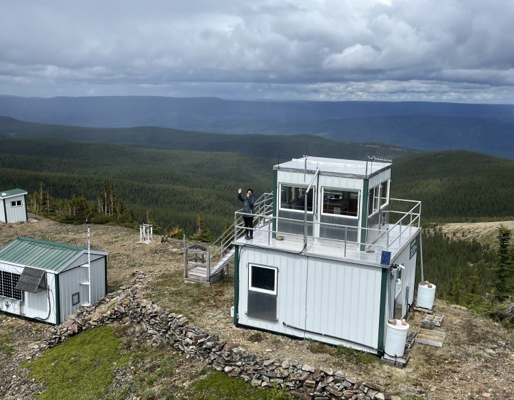 The Copton lookout is one of twelve wildfire lookout towers in the Grande Prairie Forest Area, located in the southern part of the region. The dedicated observers who staff these towers play a vital role in detecting wildfires early. Photo: June 19
GWF028 - The Hamelin Creek wildfire near Moonshine Lake Provincial Park
The Hamelin Creek wildfire, located near Moonshine Lake Provincial Park, remains out of control and is estimated at 5,557 hectares in size. Firefighters, along with heavy equipment and helicopters, continue to make steady progress in strengthening containment lines and putting out hot spots.
The dry conditions in this area are making things more challenging, as the wildfire is burning deep in the ground. This wildfire was caused by lightning.
Saddle Hills County evacuation alert
A Saddle Hills County evacuation alert remains for areas near the wildfire. Residents should remain prepared to leave on short notice if conditions change.
You can also visit the Saddle Hills County webpage or Facebook page for more information.
Moonshine Lake Provincial Park
For the most up to date information, please see the Alberta Parks website.
GWF040 - Wildfire south of Grande Prairie
Alberta Wildfire continues to respond to this wildfire, located approximately 78 km south of Grande Prairie and 19 km east of Highway 40. The wildfire is estimated at 248 hectares and is classified as being held.
Steep terrain has made some areas difficult to access, but firefighters, heavy equipment and helicopters remain actively engaged in suppression efforts. Wildlife encounters have also posed challenges for firefighters working in this remote region, requiring extra caution and awareness on the ground.
GBZ001 - Kiskatinaw River wildfire
This wildfire, which originated in British Columbia, remains classified as being held. The wildfire is estimated at 26,372 hectares and is located near the Alberta–British Columbia border, approximately 68 km west of Grande Prairie.
Unburned trees and vegetation within the fire perimeter are expected to continue to burn, producing visible smoke. Firefighters are focused on "mop up" and patrol, a critical phase of wildfire response that ensures the fire is contained. Mop up and patrol involves carefully inspecting the burned area to locate and extinguish any remaining hotspots. This work is methodical and physically demanding but is necessary to ensure the fire does not spread later in the summer.
Response to the Kiskatinaw has been a multi-agency response. Watch a video of what the BC Wildfire Service has been doing in response to this wildfire and to learn more about "mop up" operations on the Kiskatinaw River wildfire.
The BC Wildfire Service is the primary agency working to contain this wildfire. Alberta Wildfire is supporting these efforts as needed.
For more information on this wildfire and others in B.C., visit the BC Wildfire Service website.
Grande Prairie Forest Area statistics
Since January 1, there have been 60 wildfires in the Grande Prairie Forest Area, burning a total of 5,822 hectares.
Learn more about active wildfires, their locations and stats on the interactive map on our wildfire status page.
Lightning-caused wildfires
Lightning is typical this time of year and has been detected across our forest area. This increases the potential for new wildfire starts. Lightning-caused wildfires can smoulder beneath the surface for several days before becoming active and visible when conditions are favourable, particularly during dry and windy weather.
If you see smoke or other signs of wildfire activity, report it immediately by calling 310-FIRE (3743). Early reporting helps firefighters respond more quickly and reduces the risk of wildfire spread.
Contact info
Kassey Zatko
780-538-5327
[email protected]
Published on July 3, 2025 3:57 pm