Call 310-FIRE (3473) to report a wildfire in a forested area.
Overview
Fire danger is a general assessment of the fire environment that determines the ease of ignition, rate of spread, difficulty of control and fire impact.
Maps are generated to guide management decisions for wildfire personnel, fire managers, and other stakeholders in the Forest Protection Area of Alberta. They are produced daily during wildfire season, from March 1 to October 31. The final map will remain in place until next wildfire season, once snow has melted.
Fire Weather Index System
Fire danger is based on the Fire Weather Index System, which is derived from daily observations of temperature, relative humidity, precipitation and wind direction and speed. Low numbers mean wet and high numbers mean dry.
Actual fire danger maps
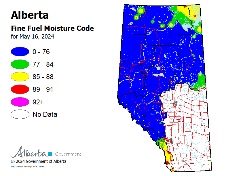
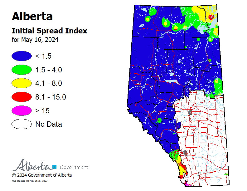
The following maps of Fire Weather Index codes indicate actual conditions, based on daily observations recorded at 1 pm.
-
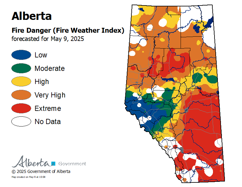
Fire danger
Fire danger is a relative index depicting forest environment conditions, how a fire will behave and how much damage a fire could do.
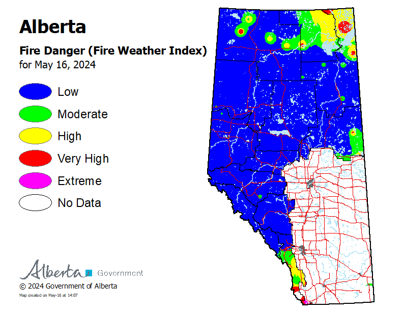
How to interpret the fire danger map
Low: Fire can still ignite but is not expected to spread to deeper vegetation layers or larger fuels, such as trees.
Moderate: Creeping or gentle surface fire is likely.
High: Forest fuels are dry and fire risk is serious. Moderate to vigorous surface fire is expected, which may spread to treetops. Conditions may be challenging for fire suppression efforts.
Very high: High-intensity fire is expected and likely to spread to treetops. Fire is expected to start easily and to challenge suppression efforts.
Extreme: Forest fuels are extremely dry and pose a very serious fire risk. Fast-spreading, high-intensity fires are likely, which are very difficult to control.
-
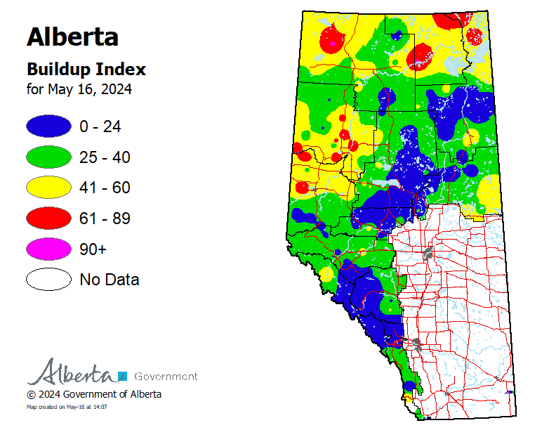
Buildup Index
The buildup index is a numeric rating of the total amount of fuel available for combustion, based on the duff moisture code and the drought code.
-
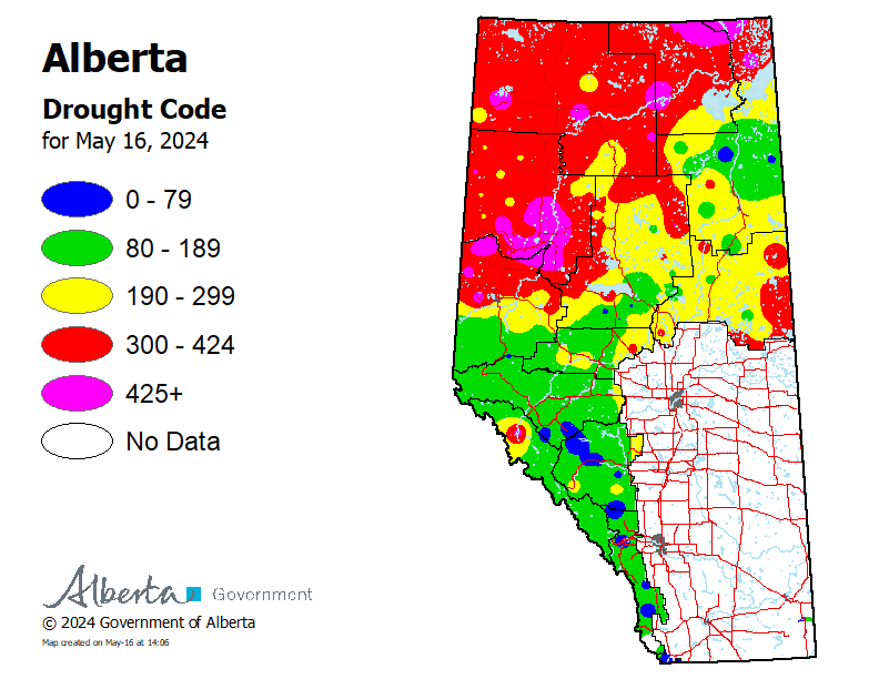
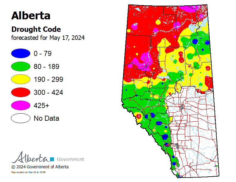
Drought Code
Drought code indicates the dryness of large vegetation, such as trees, and deep, compact organic layers.
-
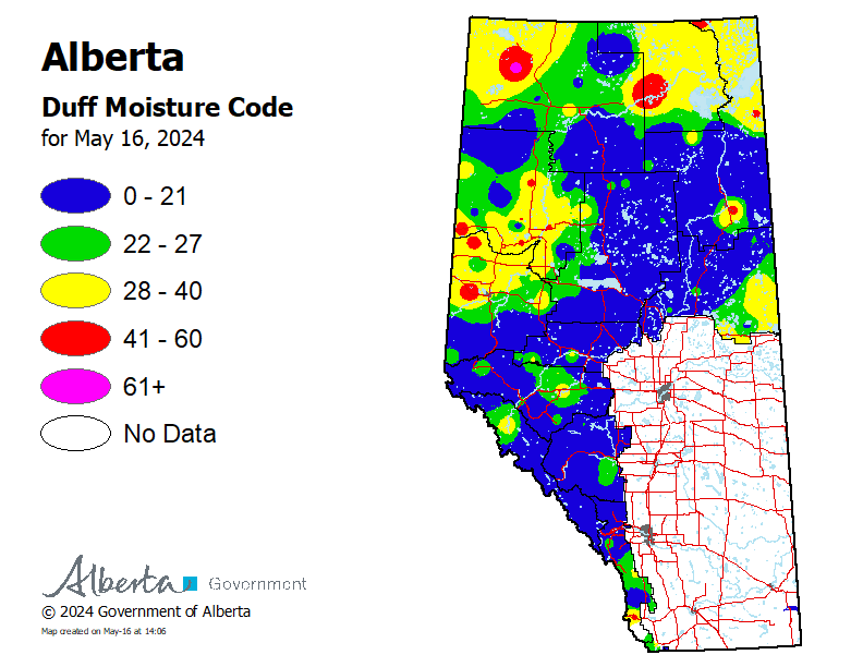
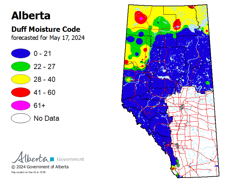
Duff Moisture Code
Duff moisture code indicates the dryness of medium-sized vegetation and loosely compacted organic layers of moderate depth.
-
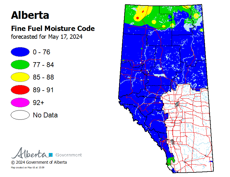
Fine Fuel Moisture Code
Fine fuel moisture code indicates the dryness of small forest vegetation, such as surface litter, leaves, needles and small twigs.
-
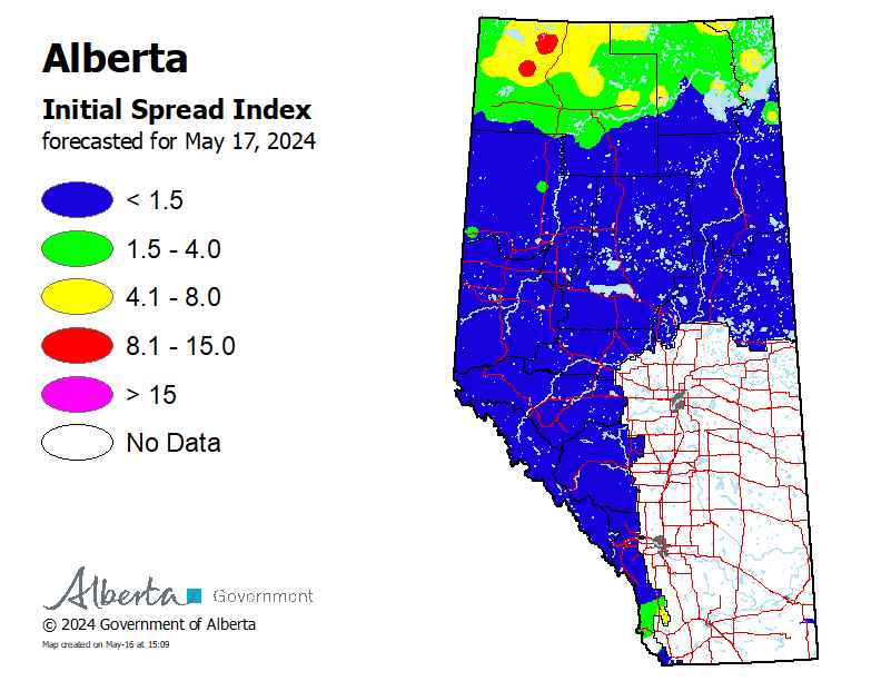
Initial Spread Index
The initial spread index is a numeric rating of the expected rate of fire spread based on wind speed and the fine fuel moisture code.
Forecasted fire danger maps
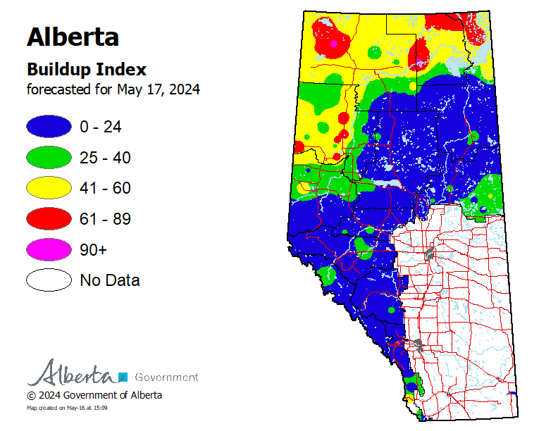
The following maps of Fire Weather Index codes indicate forecasted conditions for the next day, based on the next day’s weather forecast created at 3 pm.
-
Fire danger
Fire danger is a relative index depicting forest environment conditions, how a fire will behave and how much damage a fire could do.
How to interpret the fire danger map
Low: Fire can still ignite but is not expected to spread to deeper vegetation layers or larger fuels, such as trees.
Moderate: Creeping or gentle surface fire is likely.
High: Forest fuels are dry and fire risk is serious. Moderate to vigorous surface fire is expected, which may spread to treetops. Conditions may be challenging for fire suppression efforts.
Very high: High-intensity fire is expected and likely to spread to treetops. Fire is expected to start easily and to challenge suppression efforts.
Extreme: Forest fuels are extremely dry and pose a very serious fire risk. Fast-spreading, high-intensity fires are likely, which are very difficult to control.
-
Buildup index
The buildup index is a numeric rating of the total amount of fuel available for combustion, based on the duff moisture code and the drought code.
-
Drought code
Drought code indicates the dryness of large vegetation, such as trees, and deep, compact organic layers.
-
Duff moisture code
Duff moisture code indicates the dryness of medium-sized vegetation and loosely compacted organic layers of moderate depth.
-
Fine fuel moisture code
Fine fuel moisture code indicates the dryness of small forest vegetation, such as surface litter, leaves, needles and small twigs.
-
Initial spread index
The initial spread index is a numeric rating of the expected rate of fire spread based on wind speed and the fine fuel moisture code.
Fire behaviour
Fire behaviour is based on the Fire Behaviour Prediction System, which provides quantitative estimates of potential fuel consumption, fire intensity and head fire spread rate.
Maps are produced daily during wildfire season, from March 1 to October 31.
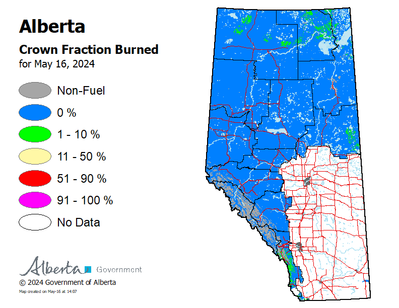
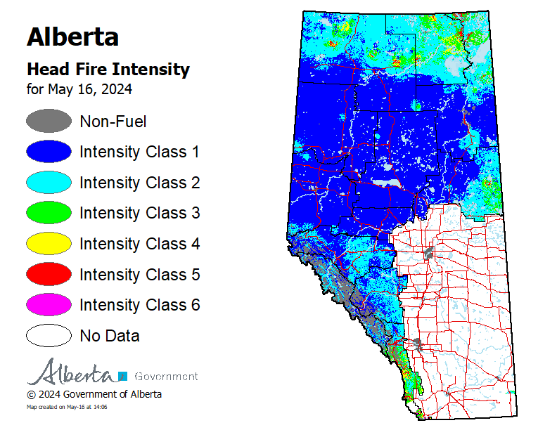
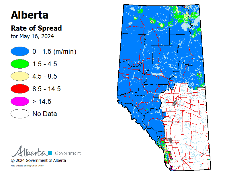
Actual fire behaviour maps
The following fire behaviour maps indicate actual conditions, based on Fire Weather Index codes calculated at 1 pm.
-
Crown fraction burned
The crown fraction burned is the predicted fraction of tree crowns consumed by the fire. Ten percent or less indicates surface fire, 10 to 90% indicates intermittent crown fire and 90% or more indicates continuous crown fire.
-
Head fire intensity
Head fire intensity is the predicted intensity or energy output of the fire at the front or head of the fire, used to estimate the difficulty in controlling a fire. It is measured in kilowatts per metre (kW/m).
-
Rate of spread
Rate of spread is the predicted speed of the fire at the front or head of the fire, where the fire moves fastest. It is measured in metres per minute (m/min).
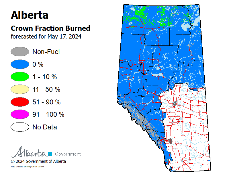
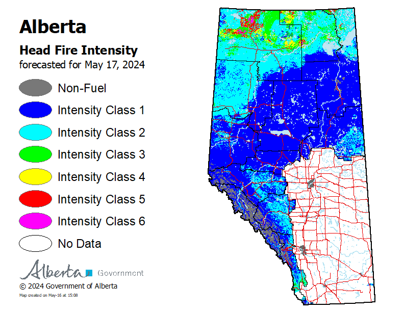
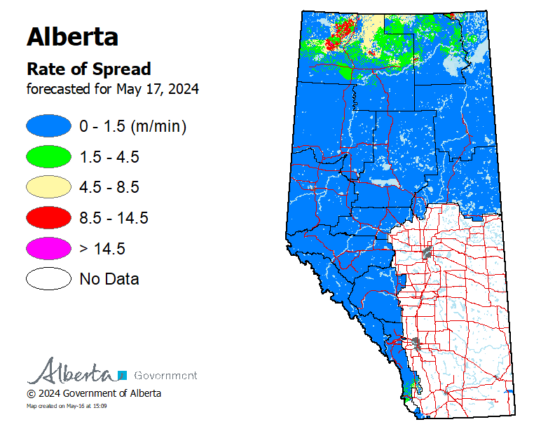
Forecasted fire behaviour maps
The following fire behaviour maps indicate forecasted conditions for the next day, based on forecasted Fire Weather Index codes calculated at 3 pm.
-
Crown fraction burned
The crown fraction burned is the predicted fraction of tree crowns consumed by the fire. Ten percent or less indicates surface fire, 10 to 90% indicates intermittent crown fire and 90% or more indicates continuous crown fire.
-
Head fire intensity
Head fire intensity is the predicted intensity or energy output of the fire at the front or head of the fire, used to estimate the difficulty in controlling a fire. It is measured in kilowatts per metre (kW/m).
-
Rate of spread
Rate of spread is the predicted speed of the fire at the front or head of the fire, where the fire moves fastest. It is measured in metres per minute (m/min).
Contact
For questions about weather data, forecasts and observations:
Email: [email protected]
Information line: 1-866-394-3473 (FYI-FIRE)
Media inquiries: 780-420-1968
Email: [email protected]