Government mail service may be affected by the Canada Post labour disruption. Learn about how critical government mail will be handled.
Very High wildfire danger
The fire danger in the Edson Forest Area remains very high. The area experienced isolated showers and did not receive wide spread rain.
A wildfire will ignite very easily in these conditions and can quickly grow out of control. High temperatures and low humidity will cause intense fire behavior. Strong winds are expected later today, a wildfire could move quickly under those conditions. Avoid all outdoor activities that have the potential to cause a fire from a spark, friction or hot exhaust.
Wildfire situation
Since January 1, there have been 38 wildfires in the Edson Forest Area burning a total of 585 hectares (ha). View active wildfires, their locations and stats on the interactive map on our wildfire status page.
EWF038 near Cynthia
EWF038 is located 12 km northeast of Cynthia, 10 km east of highway 753, 7 km north of highway 621 on the northeast corner of Sink Hole Lake. The wildfire is now estimated to be 16 ha and growing towards the north northwest and classified as out of control.
Alberta Wildfire firefighters, helicopters and airtankers are responding. Heavy equipment has been dispatched to the incident.
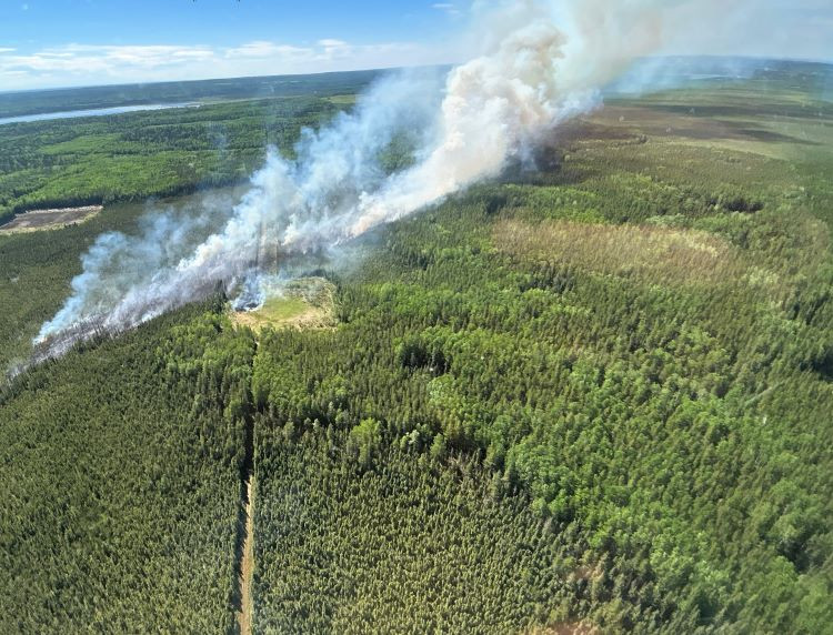 EWF038 is growing towards the north northeast near Cynthia (May 30, 2025 at 4:00 p.m.).
EWF036 near Peers
EWF036 is located 0.5 km south of the Peers transfer station and 1.5 km to the railroad south of Peers. The wildfire started on the west side of highway 32 and crossed over onto the east side on May 29. The wildfire is now estimated to be 285 ha in size. The wildfire remains classified as out of control and under investigation.
Alberta Wildfire firefighters, heavy equipment, helicopters and airtankers alongside Yellowhead County Fire Department responded to this wildfire. Firefighters worked late into the evening and heavy helicopters equipped with night vision equipment tanked water through the night. Heavy equipment operators worked through the night and successfully built a containment line surrounding the entire wildfire. Containment lines are built to prevent the wildfire from spreading however under windy conditions, the fire can spot across the line.
The wind is currently spotting this wildfire across the containment line. Helicopters and airtankers are actioning the wildfire to prevent further spread.
The forecast calls for a high of 24C and 20% relative humidity creating crossover conditions. This occurs when the temperature is greater then the relative humidity, making perfect conditions for a wildfire to spread. The winds are anticipated to come from the southwest 15-20 gusting to 40 km/h, any wildfire activity would probably move towards the northeast.
Yellowhead County has issued an evacuation order for Peers and surrounding area. Visit the Alberta Emergency Alert or download the app for information or visit their social media page - Yellowhead County Facebook. For highway closures, visit Alberta 511 for further information.
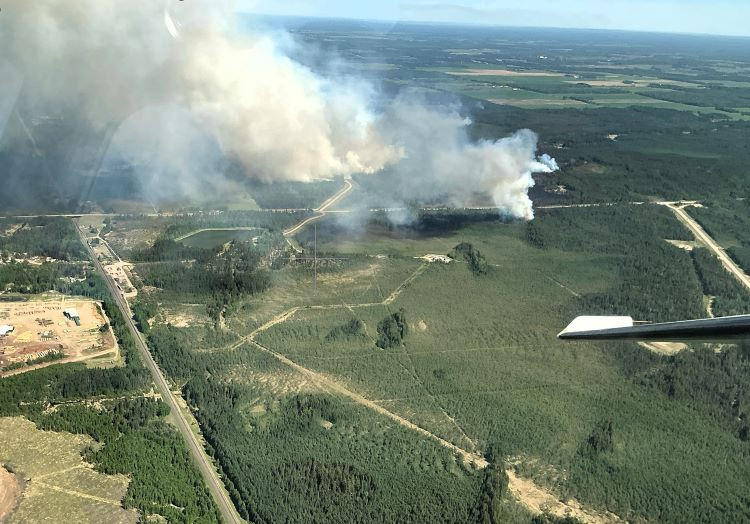 EWF036 near Peers is showing increased fire behavior (May 30, 2025 at 4:00 p.m.).
Mercoal Creek Wildfire (EWF030)
EWF030 is located 6 km west of Mercoal and 16 km southwest of Robb. The wildfire is now classified as being held and estimated to be 224 ha. This wildfire was caused by lightning.
Due to hot temperatures and windy conditions, the wildfire has become active. Smoke will be visible. Firefighters continue working to contain the wildfire with the assistance of water trucks. They're searching for and extinguishing hotspots which often involves digging deep into the ground and dousing the smoldering fire with water.
Yellowhead County has indicated that there is no evacuation order for the community of Robb or Mercoal at this time; however, having a plan and being prepared is always a good idea. More information can be found on the preparedness website.
Lightning-caused wildfires
Lightning-caused wildfires are a common natural occurrence in Alberta, making up approximately 30% of the wildfires that occur each year in the Edson Forest Area.
Lightning-caused wildfires can be deceptively delayed, sometimes taking days to become visible after the initial strike. When lightning hits a tree or dry vegetation, it can ignite a slow-burning fire deep within organic layers of soil or in the core of a tree, where it smolders quietly without producing visible flames or smoke. These "holdover fires" can persist unnoticed, insulated by damp soil or dense vegetation, until weather conditions change—such as drier air or stronger winds—allowing the fire to surface and spread rapidly. This delayed ignition makes detection and response particularly challenging, increasing the risk of the fire growing out of control before it's even discovered.
The Edson Forest Area has firefighters and equipment ready to respond for the anticipated increase in fire danger and thunderstorms in the forecast. Call 310-FIRE if you see smoke or flames and suspect it's a wildfire. Learn more about how to report a wildfire.
Fire ban
A fire ban is in effect for the northern and central regions of the Forest Protection Area. Under this ban, all outdoor wood fires are prohibited and existing fire permits are suspended.
Prohibited:
- All outdoor wood fires, including wood campfires on public and private land, designated firepits and backyard firepits
- Barbecue charcoal briquettes
- Fireworks and exploding targets
Allowed:
- Propane fire pits and natural gas-powered appliances
- Indoor wood fires
- Open flame oil devices
The fire ban will remain in effect until conditions improve. Visit Alberta Fire Bans for more information and to see the boundaries.
Published on May 30, 2025 4:41 pm