The fire danger in the Edson Forest Area is now moderate. Cooler temperatures and precipitation has helped reduce the fire danger. Winds are anticipated to dry fine fuels quickly. Increase fire danger is expected in the coming days.
Call 310-FIRE if you see smoke or flames and suspect it's a wildfire. Learn more about how to report a wildfire.
Wildfire situation
Since January 1, there have been 40 wildfires in the Edson Forest Area burning a total of 1,085 hectares (ha). View active wildfires, their locations and stats on the interactive map on our wildfire status page.
Yellowhead County evacuation orders
Yellowhead County has issued several evacuation alerts and orders. Visit Alberta Emergency Alert or download the app for further information and instructions. You can also find more on their preparedness website. Evacuees can check in at the Reception Centre at the Holiday Inn Express in Edson or call 1-833-334-4630. For highway closures, visit Alberta 511 for further information.
EWF038 near Cynthia
EWF038 is located 12 km northeast of Cynthia, 10 km east of highway 753. It is 7 km north of highway 621 on the northeast corner of Sink Hole Lake. The wildfire is now estimated to be 10 ha and now classified as being held. Firefighters returned today and made great progress searching for and extinguishing hotspots.
EWF036 near Peers
EWF036 is located on the south side of Peers. The wildfire started on the west side of highway 32 and crossed over onto the east side on May 29. The size is now estimated to be 728 ha in size. The wildfire remains classified as out of control and under investigation.
Alberta Wildfire firefighters, heavy equipment, helicopters and airtankers alongside Yellowhead County Fire Department continue responding to this wildfire.
Today, low to moderate fire behavior was observed with periodic precipitation throughout the day which allowed for better firefighting efforts. Heavy equipment was focusing on the west side of the wildfire. Firefighters and aircraft continue searching for and extinguishing hotspots to secure the fire line and prevent the spread of the wildfire.
Airtankers are a specialized resource. They are used to cool the edge of the wildfire as the first step to enable ground resources to construct dozer guards or other containment lines around the wildfire. Once the perimeter is established with lines, ground resources can then begin the work of extinguishing hotspots inside the perimeter. Helicopters with buckets or heavy helicopters with water tanks can work in conjunction with firefighters, providing water when they dig into the ground or fell trees to extinguish a hotspot.
A high of 17C and 30% relative humidity will help keep fuels from drying but winds from the northwest 25-30 gusting to 40 km/h will dry fine fuels and encourage fire spread. Significant smoke may be visible from within the fire perimeter.
Firefighters, helicopters and heavy equipment will work again until late into the evening. Yellowhead County firefighters are also continuing to assess and maintain the sprinkler protection in Peers and surrounding area, the elevated structure protection is completed and operational. They have maintained a 24 hour presence in the community.
CN Rail's Neptune firefighting train has also been an asset in assisting with fire suppression. They worked in conjunction with Yellowhead County Fire Dept and AB Wildfire in stopping the progression of the wildfire moving towards the southern perimeter of Peers and maintaining their line. They're currently stationed south of Peers and ready to action if needed.
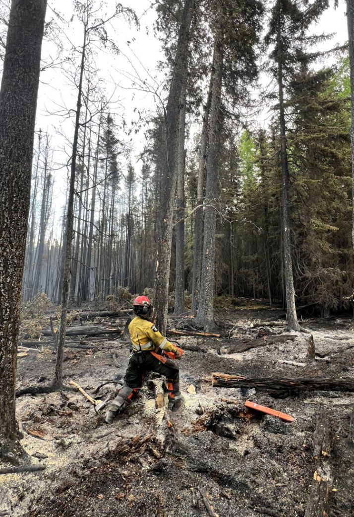 Firefighters are making good progress extinguishing hotspots to prevent the wildfire from spreading (EWF036 on June 1, 2025).
EWF030 Mercoal Creek Wildfire
EWF030 is located 6 km west of Mercoal and 16 km southwest of Robb. The wildfire remains classified as out of control and estimated to be 320 ha in size. This wildfire was caused by lightning.
This wildfire demonstrated extreme fire behavior yesterday afternoon and smoke could be seen from a far distance. By late afternoon, the temperatures dropped significantly and the fire received hail and snow, dampening the fire behavior.
Despite the rain and snowfall, it only dampened the surface, like leaves and other fine vegetation without soaking deeper into organic material or tree roots. Because wildfires can smolder underground in root systems, peat layers, or decaying logs, this wildfire will continue to produce smoke and could resume with flame.
Today, firefighters, water trucks and heavy equipment searched for and extinguishing hotspots, which involves digging deep into the ground and dousing the smoldering fire with water. They'll continue this work until the hotspots are extinguished.
FireSmart your home, farm and acreage
Your actions today can minimize wildfire damage to your home and property tomorrow.
Flames aren’t the only threat. An estimated 90% of homes damaged or destroyed by wildfire are ignited by embers. By taking proactive FireSmart measures around your house and yard, you can increase your properties’ resistance to wildfire.
Visit FireSmart Alberta for information on how to get your journey started.
Fire ban
A fire ban is in effect for the northern and central regions of the Forest Protection Area. Under this ban, all outdoor wood fires are prohibited and existing fire permits are suspended.
Prohibited:
- All outdoor wood fires, including wood campfires on public and private land, designated firepits and backyard firepits
- Barbecue charcoal briquettes
- Fireworks and exploding targets
Allowed:
- Propane fire pits and natural gas-powered appliances
- Indoor wood fires
- Open flame oil devices
The fire ban will remain in effect until conditions improve. Visit Alberta Fire Bans for more information and to see the boundaries.
Contact info
Caroline Charbonneau
780-740-1341
[email protected]
Published on June 1, 2025 7:03 pm