West Calgary Ring Road Confirmatory Noise Study now available.
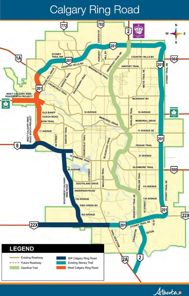
Overview
The Calgary Ring Road encircles the City of Calgary on the west side of the city connecting:
- Deerfoot Trail/Queen Elizabeth 2 Highway
- Highway 1A
- Trans-Canada Highway
- Highway 8
- Highway 22X
On the east side, it connects:
- Highway 560
- Trans-Canada Highway
- Highway 564
The ring road is part of a larger east-west/north-south trade corridor which enhances access to markets in and out of Alberta, supporting economic diversification and sustained economic growth.
Originally anticipated in fall 2024, the final section of the Calgary Ring Road opened nearly a full year ahead of schedule. The Calgary Ring Road provides 101 km of free-flow, freeway around the city, reducing congestion, improving access to hospitals, schools, workplaces and recreational amenities. It provides an important commercial goods route around the City of Calgary for the movement of goods to market within southern Alberta, and beyond.
The last segment of the West Calgary Ring Road, the final section of the ring road, opened to traffic December 19, 2023, marking the culmination of a highway project that was decades in the making. Discussions on a ring road around the City of Calgary started in the 1950s. Planning, acquisition of land and design work began in the late 1970s. Construction on the first sections of Northwest Stoney Trail began in the late 1990s.
The Calgary Ring Road includes:
- Northwest Stoney Trail (opened in Fall 2009)
- Northeast Stoney Trail (opened in Fall 2009)
- Southeast Stoney Trail (opened in Fall 2013)
- Tsuut’ina Trail (opened in Fall 2020)
- Southwest Calgary Ring Road (opened in Fall 2021)
- West Calgary Ring Road (opened in Fall 2023)
- South Bow River Bridge
-
Northwest Stoney Trail
The Northwest Stoney Trail was completed in a series of smaller projects, with construction of different sections undertaken by both the City of Calgary and the province.
- Phase 1 began with river abutment construction in 1995, with new roadway from Trans-Canada Highway to Crowchild Trail/ 85 street opening in 1997.
- Phase 2 from 85 Street to Country Hills Boulevard – new road opened in 1998.
- The province completed widening work between Nose Hill Drive and Crowchild Trail In 2004 and twinning between Crowchild Trail and Country Hills Boulevard in 2005.
- The construction of the interchange at Trans-Canada Highway and Stoney Trail began in 2004 and was completed in 2007.
-
Northeast Stoney Trail
The Northeast Stoney Trail project included:
- 21 km of divided highway
- 15 km of new 4-lane divided roadway
- 6 km of a new 6-lane divided roadway between Highway 2 and Highway 1A.
- interchanges at:
- Highway 2 and Stoney Trail
- 44 Street and Country Hills Boulevard
- Airport Road and McKnight Boulevard
- Highway 1 and Stoney Trail
- railway crossings:
- Twin CN Railway bridges on Stoney Trail
- a single CN Railway bridge replacement
Construction on Northeast Stoney Trail began in winter 2007 and was opened to traffic in fall 2009.
-
Southeast Stoney Trail
The Southeast Stoney Trail Ring Road portion of the Calgary Ring Road traverses around the southeast perimeter of the City of Calgary from Peigan Trail to Highway 22X.
The project included:
- approximately 25 km of 6-lane divided highway
- basic and auxiliary lanes
- 9 interchanges
- 11 intersections
- 27 bridges structures
- 1 road flyover
- 2 rail flyovers
- 3 km of pedestrian paths
Interesting facts
- 6,000 tonnes of reinforcement
- 10 million cubic metres of landfill
- 42,000 cubic metres of structural concrete
- 3 types of prefabricated beams
- 50+ metres of steel beams instead of concrete
- nearly 2.5 million man-hours (includes all construction and office workers)
- enough employee hours to build 5,000 1,000-square-foot homes
- 600,000 tonnes of asphalt
- enough to pave nearly 300,000 average sized driveways
- 5,000 tonnes of rebar
- equal to the average weight of 1,000 African elephants
- 40,000 cubic metres of concrete
- enough to fill 70,000 one-tonne pickup trucks
Construction on Southeast Stoney Trail began in spring 2012. The road was opened to traffic in fall 2013.
-
Tsuut’ina Trail
Tsuut’ina Trail, is the 12 km section of the Southwest Calgary Ring Road through the former Tsuut’ina Nation lands. It is located between Highway 8 (Sarcee Trail) and Fish Creek Boulevard SW. The origin of this road dates back to 1952, when the city first envisioned a bypass road located west of the Glenmore Reservoir. Tsuut’ina Trail serves as a link between the city and the Tsuut’ina Nation, and it makes up for about 40% of the Southwest Calgary Ring Road.
Construction began in summer 2016. Tsuut’ina Trail (Sarcee Trail to Fish Creek Boulevard) opened on October 1, 2020.
-
Southwest Calgary Ring Road
 Figure 3. Southwest Calgary Ring Road
The Southwest Calgary Ring Road connects Highway 8 and Highway 22X at Macleod Trail and included reconstruction of Glenmore Trail from Sarcee Trail to east of 37 Street. It comprises approximately 20% of the entire Calgary Ring Road.
The Southwest Calgary Ring Road includes:
- 49 bridges
- 31 km of new 6- and 8-lane divided highway
- 14 interchanges
- 3 river crossings
- 2 river realignments (Elbow River and Fish Creek)
- 2 bridge rehabilitations
- 1 road flyover
- 1 railway crossing (flyover)
- 1 tunnel
Interesting facts
- 16 million cubic metres of earth, equivalent to 1,650 NHL-sized rinks of dirt
- 13 million kilograms of rebar
- 1 million metric tonnes of asphalt
- The artwork along the Tsuut’ina Trail depicts the origin story of the Tsuut’ina Nation.
Construction began in summer 2016. Tsuut’ina Trail, (Sarcee Trail to Fish Creek Boulevard) opened on October 1, 2020 and the remaining section of the Southwest Calgary Ring Road opened to traffic in Fall 2021.
-
West Calgary Ring Road
 Figure 2. West Calgary Ring Road
The West Calgary Ring Road opened to traffic, in stages, in fall 2023; this was the final section of the Calgary Ring Road to open.
Located between Highway 8 and the Trans-Canada Highway on the west side of Calgary, the West Calgary Ring Road includes:
- 9 km of 6 and 8 lane divided highway
- 6 interchanges
- 24 bridges
- twinning the Bow River Bridge, carrying Stoney Trail over the Bow River to accommodate current and future traffic demand
The West Calgary Ring Road project included 3 segments:
North segment: This is approximately 3 km of 6- and 8-lane divided freeway between Highway 1 (Trans-Canada Highway) and the Old Banff Coach Road, including the reconstruction of approximately 5 km of Highway 1. This segment includes 18 bridges, 2 interchanges (Highway 1 and Valley Ridge Boulevard) and one flyover (1 Avenue SW).
South segment: This is approximately 4 km of 6- and 8-lane divided freeway between Old Banff Coach Road and Highway 8, with 7 bridges and 4 interchanges (Old Banff Coach Road, Bow Trail, 17 Avenue SW, Highway 8).
Bow River Bridge twinning/widening segment: This is on the northwest segment of the ring road; it includes widening about 2 km of Northwest Stoney Trail from Crowchild Trail to Scenic Acres Link.
Following completion of the West Calgary Ring Road, a confirmatory noise study was conducted to measure noise levels on the highway. See the West Calgary Ring Road Confirmatory Noise Study for more information.
News
- Christmas comes early for Calgary drivers (December 18, 2023)
- Final phase of Calgary Ring Road construction (October 19, 2023)
Contact
For highway maintenance issues:
Phone: 403-543-8750 (North Stoney Trail)
Phone: 877-898-7623 (Southeast Stoney Trail)
Phone: 403-212-0565 (Southwest Calgary Ring Road)
Phone: 403-543-8750 (West Calgary Ring Road)