Flood mitigation on the Bow River continues with the Ghost Reservoir Infrastructure Project.
Overview
Alberta’s government continues to explore options to build additional flood and drought storage capacity on the Bow River to reduce the impacts of severe weather events on Albertans and the economy.
Following a thorough feasibility study, we have decided to move forward with additional exploration of the Relocated Ghost Dam option. This is an expansion of the existing Ghost Reservoir to protect downstream communities on the Bow River and provide water security for the Bow River basin.
The Relocated Ghost Dam option is being explored further in the Phase 3 Engineering and Regulatory Approval Process.
Alternatives to the water storage options being assessed in the feasibility study were also assessed. The alternatives bring with them significant treaty rights issues, environmental impacts, regulatory challenges, and/or poor cost-benefit ratios. To date, no suitable feasible alternatives have been found that provide the water storage needed for water security during drought and mitigating flood impacts without significant issues.
Although the Phase 1 Conceptual Assessment and Phase 2 Feasibility Study and Alternatives Assessment were led by Alberta Environment and Protected Areas, Phase 3 is being led by Alberta Transportation and Economic Corridors (TEC). Information from Phase 1 and Phase 2 has been transferred to TEC.
In Phase 3, the Bow River Reservoir Options initiative will be known as the Ghost Reservoir Infrastructure Project (GRIP), as the Relocated Ghost Dam option was selected in Phase 2. More information regarding the project will be shared with the public when known.
Email questions regarding GRIP to [email protected].
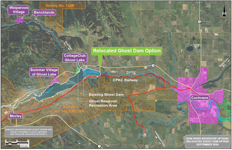
Study corridor map
The map below shows the feasibility study location of the Relocated Ghost Dam. Details regarding the dam location and reservoir extent are subject to change as additional data are collected and analysis is completed.
Figure 1. Feasibility study location and extent of the Relocated Ghost Dam reservoir option.
Project timeline and phases
The selection and potential implementation of a reservoir option on the Bow River upstream of Calgary is being approached in 4 phases:
- Phase 1: Conceptual assessment (completed March 2020)
- Phase 2: Feasibility study (completed March 2025)
- Phase 3: Engineering and regulatory approval process (commencing)
- Phase 4: Procurement, construction and commissioning (potential)
Phase 3. Engineering and regulatory approvals process
Phase 2. Feasibility study
Phase 2. Alternatives assessment
Findings supported the alternative assessment objective to confirm whether or not there were any suitable alternatives to a reservoir. No suitable feasible alternatives have been found that provide the water storage needed for water security during drought and mitigating flood impacts without significant issues.
Phase 1. Conceptual assessment
Additional information
- Frequently asked questions – These questions came from information sessions held throughout Phase 2 of the initiative. We want to share broadly as these questions have been commonly raised throughout the initiative.
- Bow River Reservoir Options – Phase 2: Feasibility Study Main Report
- Bow River Reservoir Options - Phase 1: Conceptual Assessment – Main Report
Prepared by WSP (formerly Wood Environment & Infrastructure Solutions), 2020 - Bow River Water Management Project: Advice to Government on water management in the Bow River Basin
Prepared by the Bow River Working Group, 2017 - Option Evaluation Framework Factsheet
- What We Heard Report
Contact
Connect with the Ghost Reservoir Infrastructure Project:
Email: [email protected]
For questions about Phase 1 and Phase 2:
Email: [email protected]