The wildfire danger in the Slave Lake Forest Area is moderate.
Firefighters are urging everyone to continue using caution and do their part to prevent wildfires. If you're working or enjoying the outdoors, avoid any activities that could create sparks. Always ensure your campfires are fully extinguished before leaving.
Wildfire situation
Since January 1, 2025 there have been 156 wildfires reported in the Slave Lake Forest Area, burning a total of 378,385 hectares (ha).
See the Alberta Wildfire Status Dashboard for up-to-date information on wildfire locations, status, size, statistics and more.
There are 13 active wildfires in the Slave Lake Forest Area, 5 are out of control, 5 are being held and 3 are under control.
Firefighters in helicopters responded to 2 new wildfires yesterday, both were quickly contained and extinguished.
SWF149, which occurred on July 20, is located approximately 12 km east of Marten Beach and 20 km north of Slave Lake. The wildfire is 21 ha in size and is classified as being held. Firefighters supported by helicopters and water trucks continue to focus on extinguishing hot spots along the established containment lines.
SWF150, located approximately 29 km east of Bigstone Cree Nation on North Wabasca Lake, is 10 ha in size and is classified as being held. Firefighters supported by a helicopter continue to extinguish hot spots.
SWF153, located east of Utikuma Lake, is 5 ha in size and is classified as under control. Firefighters supported by a helicopter continue to extinguish hot spots.
Red Earth East Complex
The Red Earth East Complex includes 8 active wildfires that are located east of Highway 88.
Map of the Red Earth East Complex
- Out of control: SWF085, SWF089, SWF092, SWF094 and SWF100.
- Being held: SWF095, SWF099 and SWF115.
Due to reduced fire activity and a low risk of the wildfire spread, the evacuation alert has been lifted for the communities of Red Earth Creek, Loon Lake, Trout Lake, and Peerless Lake.
Light rain will continue today and has helped keep fire activity low. However, these wildfires are large and will take considerable time and effort to fully extinguish. Firefighters, supported by aircraft and heavy equipment, continue to make good progress on active areas of the wildfires.
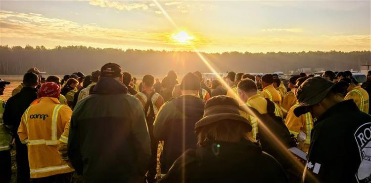 Every morning all firefighters attend a safety briefing. July 24, 2025.
SWF085, which impacted the community of Chipewyan Lake, is 137,021 ha in size and is classified as out of control. Firefighters in a helicopter continue to monitor the wildfire. The wildfire threat to the community remains minimal; however, an evacuation order remains in effect for Chipewyan Lake.
SWF089, located approximately 5.5 km east of Peerless Lake, is 12,920 ha in size and remains classified as out of control. Firefighters will continue suppression efforts on this wildfire today.
SWF092, located approximately 7 km southeast of Red Earth Creek and 8.5 km west of Trout Lake, is 82,399 ha in size and classified as out of control. Firefighters and helicopters with buckets continue to work on continue extinguishing hotspots within the wildfire perimeter. A night vision-equipped helicopter with a bucket continued suppression efforts overnight.
SWF094, located approximately 31 km northwest of Chipewyan Lake, is 73,046 ha in size and remains classified as out of control. Firefighters with support from helicopters with buckets continue suppression efforts on this wildfire. A night vision-equipped helicopter continued dropping water on the west side of the wildfire overnight.
SWF095, located approximately 5 km from Peerless Lake and 7 km from Trout Lake, is 1,314 ha in size and is classified as being held. Firefighters continue to monitor the wildfire, and very little smoke has been observed.
SWF100, located approximately 5 km west of Peerless Lake, is 18,442 ha in size and is classified as out of control. Firefighters and helicopters with bucket are working to extinguish hot spots on the southwest, north and east side of the wildfire. This wildfire does not pose a threat to Highway 686.
Red Earth Creek Airport is an Active Wildfire Worksite
Alberta Wildfire would like to remind the public that the Red Earth Creek Airport is currently an active wildfire response site. The Red Earth Creek Airport is currently being used as a staging area for personnel, helicopters, and equipment. This is to support ongoing firefighting operations on the Red Earth East Complex. Helicopters and heavy equipment are operating regularly, and unauthorized access creates a serious risk.
For your safety and ours, please avoid the area.
For information about the wildfires in the Red Earth East Wildfire Complex, please contact Randi Adams at 780-404-9186 or by email [email protected].
Smoky conditions
Smoky conditions may persist in the Slave Lake Forest Area. To find the source of the smoke, visit FireSmoke Canada. If you have smoke related health concerns, call Health Link 24/7 by dialing 811 or visit Alberta Health Services.
Fire advisory
A fire advisory is in effect for the Slave Lake Forest Area, due to current and expected conditions. Under this advisory:
- Existing fire permits are valid.
- New fire permits will be issued on a case-by-case basis, for essential burning only.
Any burning without a valid fire permit, other than a campfire is prohibited.
Visit Alberta Fire Bans for details and to view a map of the fire advisory area.
Get your free fire permit
From March 1 to October 31, a fire permit is required for any burning in the Forest Protection Area, except for a campfire. Fire permits ensure safe burning practices are being followed and allow firefighters to know where burning is approved.
Fire permits are free and can be requested online. You may also request your fire permit by calling your local forestry office.
- Slave Lake 780-849-7377
- Wabasca 780-891-3860
- High Prairie 780-523-6619
Contact info
Leah Lovequist
780-849-0945
[email protected]
Published on July 25, 2025 1:22 pm