The wildfire danger in the Slave Lake Forest Area has climbed to high. With the warm temperatures expected today, a wildfire can ignite easily and spread quickly.
Firefighters ask that everyone use caution and to do your part to prevent wildfires. When working or recreating outdoors avoid any activities that would cause sparks and make sure your campfires are extinguished.
Wildfire situation
Firefighters in helicopters responded to 2 new wildfires yesterday. Both were quickly contained. SWF151 has been extinguished and SWF152 is under control.
There are 13 active wildfires in the Slave Lake Forest Area, 6 are out of control, 4 are being held and 3 are under control.
Since January 1, 2025 there have been 152 wildfires reported in the Slave Lake Forest Area, burning a total of 378,378 ha.
See the Alberta Wildfire Status Dashboard for up-to-date information on wildfire locations, status, size, statistics and more.
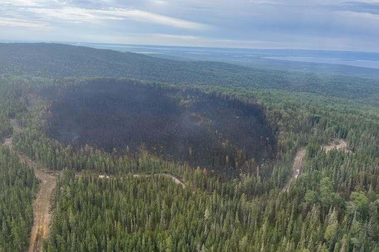 Firefighters continue to make good progress on SWF149. With firefighting efforts and cool weather, the fire activity is minimal, and risk of spread is low. July 23, 2025 9:30 am
SWF149 is located approximately 12 km east of Marten Beach and 20 km north of Slave Lake. This wildfire was accurately measured and is 21.5 hectares (ha) in size. Although the wildfire is classified as out of control, fire activity is minimal and the risk of further spread is low. Firefighters, supported by helicopters and water trucks, are working along the established containment lines to extinguish hot spots.
SWF150 is located approximately 29 km east of Bigstone Cree Nation on North Wabasca Lake. This wildfire is 10 ha in size and thanks to the hard work of firefighters and aircraft pilots the wildfire is being held. Firefighters supported by a helicopter continue to extinguish hot spots.
Smoky conditions
Smoky conditions may persist in the Slave Lake Forest Area. To find the source of the smoke, visit FireSmoke Canada. If you have smoke related health concerns, call Health Link 24/7 by dialing 811 or visit Alberta Health Services.
Red Earth East Complex
Map of the Red Earth East Complex
The Red Earth East Complex includes 8 wildfires that are located east of Highway 88.
- 5 are out of control: SWF085, SWF089, SWF092, SWF094 and SWF100.
- 3 are being held: SWF095, SWF099 and SWF115.
There has been no significant growth on any of the wildfires in the Red Earth East Complex, and they do not pose a risk to any communities or highways at this time. Smoke may still be visible to nearby communities and along Highway 88 as it drifts from areas burning within the interior of the wildfires. Firefighters supported by aircraft and heavy equipment continue steady progress in priority areas on these wildfires.
SWF085 impacted the community of Chipewyan Lake, is 137,021 ha in size and is classified as out of control. The wildfire threat to the community of Chipewyan Lake remains minimal. Firefighters continue to monitor the wildfire, and a specialized crew in danger tree removal is assessing the community of Chipewyan Lakes.
SWF089 located approximately 5.5 km east of Peerless Lake, is 12,920 ha in size and remains classified as out of control. Firefighters are being supported by helicopters conducting bucket operations along the west and south side of the wildfire.
SWF092 located approximately 7 km southeast of Red Earth Creek and 8.5 km west of Trout Lake, is 82,398 ha in size and classified as out of control. Heavy equipment is building containment line on the southwest corner of the wildfire near Cranberry Lake. Firefighters and helicopters conducting bucket operations are extinguishing hot spots focusing on the northwest, southwest and east side of the wildfire. A night vision equipped helicopter continued dropping water on the southwest corner of the wildfire overnight.
SWF094 located approximately 31 km northwest of Chipewyan Lake, is 73,045 ha in size and remains classified as out of control. Firefighters and helicopters with buckets are extinguishing hot spots located on the west side of the wildfire.
SWF095 located approximately 5 km from Peerless Lake and 7 km from Trout Lake, is 1,313 ha in size and is classified as being held. Firefighters continue to monitor the wildfire, and very little smoke has been observed.
SWF100 is located approximately 5 km west of Peerless Lake, is 18,441 ha in size and is classified as out of control. Firefighters and helicopters conducting bucket operations are working to extinguish hot spots on the southwest and north side of the wildfire. This wildfire does not pose a threat to Highway 686.
An evacuation order remains in effect for Chipewyan Lake.
A 2-hour evacuation alert remains in effect for the communities of Red Earth Creek, Loon Lake, Trout Lake and Peerless Lake.
For information about the wildfires in the Red Earth East Wildfire Complex, please email [email protected].
Fire advisory
A fire advisory is in effect for the Slave Lake Forest Area, due to current and expected conditions. Under this advisory:
- Existing fire permits are valid.
- New fire permits will be issued on a case-by-case basis, for essential burning only.
Any burning without a valid fire permit, other than a campfire is prohibited.
Visit Alberta Fire Bans for details and to view a map of the fire advisory area.
Get your free fire permit
From March 1 to October 31, a fire permit is required for any burning in the Forest Protection Area, except for a campfire. Fire permits ensure safe burning practices are being followed and allow firefighters to know where burning is approved.
Fire permits are free and can be requested online. You may also request your fire permit by calling your local forestry office.
- Slave Lake 780-849-7377
- Wabasca 780-891-3860
- High Prairie 780-523-6619
Contact info
Leah Lovequist
780-849-0945
[email protected]
Published on July 23, 2025 11:19 am