The wildfire danger in the Slave Lake Forest Area is now high. Wildfires can still start easily and may spread quickly, especially if temperatures increase and winds pick up. Conditions have improved slightly, but caution is still needed when spending time in forested areas.
Wildfire situation
There are 12 active wildfires in the Slave Lake Forest Area, 6 are out of control, 3 are being held and 3 are under control.
See the Alberta Wildfire Status Dashboard for up-to-date information on wildfire locations, status, size, statistics and more.
Since January 1, 2025 there have been 142 wildfires reported in the Slave Lake Forest Area, burning a total of 372,838 hectares (ha).
Red Earth East Complex
The Red Earth East Complex includes 8 active wildfires that are located east of Highway 88.
- Out of control: SWF085, SWF089, SWF092, SWF094 and SWF100.
- Being held: SWF095, SWF099 and SWF115.
Map of the Red Earth East Complex
Yesterday and this morning, varying amounts of rain were recorded over the fire area from 7-2 mm. This supported firefighting operations by lowering the fire behavior. Firefighters supported by heavy equipment and helicopters with buckets, continue to extinguish hot spots across the wildfires in the complex. Firefighters continue to make good progress, putting out hot spots farther along the containment lines than where they worked the previous day.
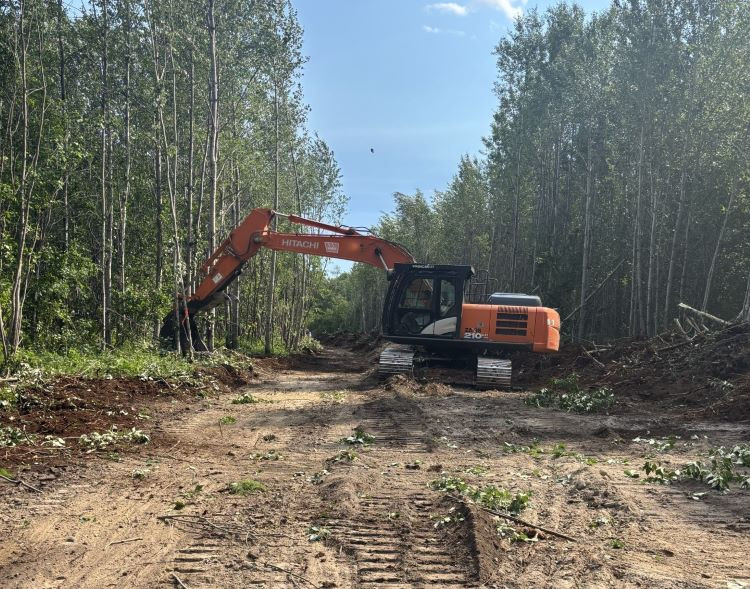 Excavators work alongside firefighters to dig up ash pits as part of wildfire operations. Photo taken July 11.
SWF085, which impacted the community of Chipewyan Lake, is 135,971 ha in size and is classified as out of control. The wildfire threat to the community of Chipewyan Lake remains minimal. Firefighters in a helicopter continue to monitor the wildfire and have reported very little fire activity over the past several days. Any new smoke sightings are being addressed by helicopters equipped with water buckets.
SWF089, located approximately 5.5 km east of Peerless Lake, is 12,920 ha in size and is classified as out of control. Fire activity continues to be low, and firefighters are extinguishing hot spots on the southwest side of the wildfire.
SWF092, located approximately 7 km southeast of Red Earth Creek and 8.5 km west of Trout Lake, is 79,577 ha in size and is classified as out of control. Firefighters, with the support from helicopters with buckets, are extinguishing hot spots across the wildfire. Heavy equipment is building containment lines on the south end of the wildfire, progressing further every day. Firefighters are getting extra help from heavy machinery that’s digging into deep ash pits to expose hidden hot spots. A specially outfitted helicopter and trained personnel are using hoists to lower tools and supplies directly to the fire line.
SWF095, located approximately 5 km from Peerless Lake and 7 km from Trout Lake is 1,307 ha in size and is classified as being held. Firefighters are monitoring this wildfire and have observed smoke. Unburned vegetation within the interior of the wildfire continues to ignite, and smoke remains visible. There is no threat of fire spread to nearby communities.
SWF100, located approximately 5 km west of Peerless Lake, is 18,376 ha in size and is classified as out of control. Firefighters are now working on the south side of the wildfire, extinguishing hot spots along containment lines with the support of helicopters with buckets. The firefighters are using the helipads that the hoist-equipped helicopter and hoist-trained crew created for easier access. An expert team is clearing fire-damaged trees that could pose a danger to crews working on the ground.
Evacuation information
- An evacuation order remains in effect for the communities of Chipewyan Lake, and Trout Lake and Peerless Lake.
- A 2-hour evacuation alert remains in effect for the communities of Red Earth Creek and Loon Lake.
For information about the wildfires in the Red Earth East Wildfire Complex, please email [email protected].
Blue Sky and Edith Lake wildfires (SWF088 and SWF076)
The Blue Sky Wildfire (SWF088) and the Edith Lake Wildfire (SWF076) are both classified as under control. Infrared scans have been completed on both wildfires to help identify any remaining hot spots. Based on these results, operations will continue working to extinguish the fires, using heavy equipment to support ongoing reclamation efforts.
Smoke conditions
Smoky conditions are expected to continue in the area due to ongoing wildfire activity across Canada. FireSmoke Canada provides hourly forecasts of smoke concentrations and identifies the source wildfires. If you have smoke related health concerns, call Health Link 24/7 by dialing 811 or visit Alberta Health Services.
Lightning caused wildfires
Recent lightning in the area may have started wildfires that are still smoldering unseen and could flare up later when conditions are right. If you see smoke in the forest or signs of wildfire, report it immediately by calling 310-FIRE (3473). Quick reporting helps wildfire crews respond faster and reduces the risk of wildfires spreading.
Get your free fire permit
You will need a fire permit for any burning in the Forest Protection Area, except for a campfire, from March 1 to October 31. Fire permits ensure safe burning practices are being followed and allow staff to know where burning is approved so firefighters and aircraft are free to fight wildfires.
Fire permits are free and can be requested online. Visit firepermits.alberta.ca to request your fire permit online. You may also request your fire permit by calling your local forestry office.
- Slave Lake 780-849-7377
- Wabasca 780-891-3860
- High Prairie 780-523-6619
For more details about safe burning practices, see our safe burning webpage.
Contact info
Allanah McLean
403-418-5023
[email protected]
Published on July 13, 2025 10:57 am