Due to cooler temperatures and scattered rain showers the fire danger is now low.
However, wildfires can still ignite, especially when windy conditions develop. It’s important to continue using caution when spending time outdoors and to stay mindful of any activity that could accidentally start a wildfire.
Red Earth East Complex
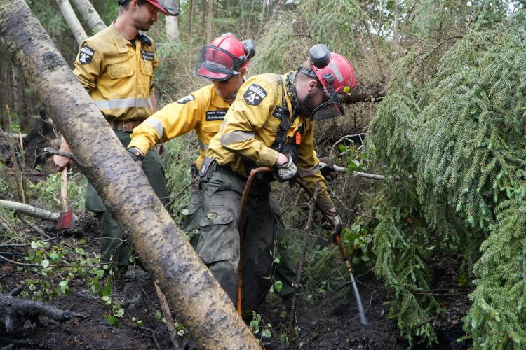
Alberta Wildfire crews extinguishing hotspots along Highway 686 in the Red Earth East Complex
The Red Earth East Complex includes 11 wildfires that are located east of Highway 88: SWF085, SWF089, SWF091, SWF092, SWF094, SWF095, SWF099, SWF100, SWF110, SWF115 and SWF135.
Yesterday, warm weather and clear skies over the fire area increased fire behaviour. The dry conditions increased smoke created by the smouldering hot spots. Today rain and thunderstorms will move across all wildfires in the complex reducing the smoke and fire activity.
Yesterday, helicopters with firefighters were able to locate and map hot spots in remote areas of the fire area. A specialized group of firefighters known as Hoist, will begin creating access points near known hotspots by helicopter. These locations will be utilized to insert firefighters in otherwise remote difficult to access sections of the fires.
SWF085, which impacted the community of Chipewyan Lake, is 138,058 ha in size and is classified as out of control. The wildfire threat to the community of Chipewyan Lake remains minimal. Firefighters in a helicopter continue to monitor the wildfire and have reported little to no fire activity over the past several days.
SWF089, located approximately 5.5 km east of Peerless Lakes, is 12,958 ha in size and is classified as out of control. Yesterday, fire activity was low and is expected to remain that way today. Firefighters are seeing an increased number of Aspen trees falling and catching fire. Firefighters are working hard to remain safe and extinguish these hot spots detected on the west side of the wildfire.
SWF092, located approximately 7 km southeast of Red Earth Creek and 8.5 km west of Trout Lake, is 82,106 hectares in size and is classified as out of control. Continued progress is being made, thanks to the cooler weather and rain in the forecast. The weather is reducing fire activity and giving helicopter pilots and firefighters the advantage of decreased fire activity. The decreased activity is helping them focus on known hotspots on the east side.
SWF095, located approximately 5 km from Peerless Lake and 7 km from Trout Lake is 1,308 ha in size and is classified as being held. Yesterday helicopters monitoring the wildfire observed smoke on the south side of the fire next to Graham Lake. Smoke like this are expected to occur but pose no threat to the fire growth. Danger Tree Assessors will be identifying and cutting down any known hazardous trees.
SWF100, located approximately 5 km west of Peerless Lake, is 18,298 ha in size and is classified as out of control. Firefighters, along with dozers and helicopters carrying water buckets are extinguishing hot spots across the fire area. Firefighters are also focused on extinguishing hot spots along highway 686.
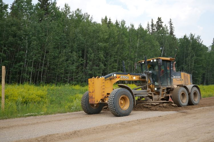
Heavy equipment remediating sections of Highway 686 in the Red Earth East Complex
Evacuation order
Firefighters are working extremely hard, but at this time, it is not safe for the residents of the following communities to return home. Multiple hot spots remain active, firefighting operations are ongoing and the wildfire perimeters have not yet been fully secured.
Wildland Urban Interface (WUI) crews continue to test pumps and sprinkler setups daily in the communities of Peerless Lake and Trout Lake.
An evacuation order remains in effect for the communities of Chipewyan Lake, and Trout Lake and Peerless Lake.
Evacuation alert
A 2 hour evacuation alert remains in effect for the communities of Red Earth Creek and Loon Lake.
Blue Sky and Edith Lake wildfires (SWF088 and SWF076)
The Blue Sky Wildfire (SWF088), located 22 km north of Marten Beach is 13,684 hectares in size and is classified as under control. Firefighters, supported by heavy equipment and helicopters, continue to extinguish hot spots on the northwest and south side of the wildfire which were identified by the recent infrared scan.
The Edith Lake wildfire (SWF076), located approximately 8 km north of Swan Hills, is 16,852 hectares in size and is classified as under control. Firefighters are monitoring this wildfire by helicopter and heavy equipment continues to reclaim the containment lines.
For information about the wildfires in the Red Earth East Wildfire Complex, please email [email protected]
Published on July 6, 2025 11:57 am