The wildfire danger in the Lac La Biche Forest Area is now extreme. Continued high temperatures, dry conditions and a lack of moisture are creating conditions where wildfires can start and spread easily. If a wildfire does start, it may spread quickly and be more challenging to control.
Wildfire situation
Hot, dry weather, increased winds, extremely dry fuels and recent lightning have created ideal conditions for wildfires to ignite and spread quickly. Six new wildfires were reported today. Firefighters, heavy equipment and aircraft are responding where needed to contain new wildfires and prevent further spread.
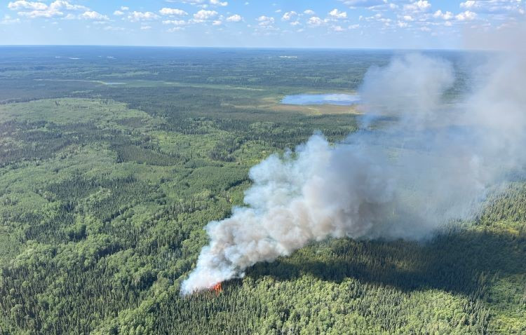 This photo shows wildfire LWF177 shortly after it was discovered on July 31. The wildfire is classified as out of control and estimated at 9.7 hectares in size.
For more information on these new wildfires, see the Alberta Wildfire Status Dashboard.
LWF172
This wildfire is estimated at 29 hectares (ha) in size and remains classified as out of control. It is 11 km east of Highway 55 and 12 km southeast of Beaver Lake Cree Nation. Firefighters continue working alongside heavy equipment and helicopters conducting bucket operations to establish containment lines and limit further spread. Night vision–equipped helicopters and heavy equipment operated through the night yesterday and will work overnight again tonight, if conditions allow.
Medley River Wildfire (LWF132)
This wildfire is now estimated at 4,683 ha in size and remains classified as out of control. It is located in the Cold Lake Air Weapons Range. This wildfire received a small amount of rain. While not enough to significantly reduce overall fire activity, the rainfall supported firefighting efforts on the north side of the fire. This reprieve helped limit further spread and contributed to reduced fire behaviour in that area.
Pelican Wildfire Complex
The Pelican Wildfire Complex includes wildfires LWF150, LWF139 and LWF131.
None of these wildfires are currently threatening communities. Sprinklers have been installed on buildings in the area as a precaution.
While there was some increased activity today, the overall size of the fires did increase in grow. Firefighters continue working to limit further spread and strengthen containment lines around these wildfires, making good progress.
- LWF150 is now estimated at 663 ha, the change in size is due to more accurate mapping. This wildfire remains classified as out of control. It is located 45 km northwest of Wandering River.
- LWF139 is estimated at 225 ha in size. This wildfire remains classified as out of control and is located on the west side of the Athabasca River, 25 km west of Highway 63.
- LWF131 is estimated at 29 ha and is now classified as under control.
Wildfire statistics
There are currently 20 active wildfires burning in the Lac la Biche Forest Area, with 5 classified as out of control, 2 classified as being held and 13 classified as under control.
Since January 1, 2025, there have been 178 wildfires in the Lac La Biche Forest Area.
For up-to-date information on wildfire locations, status, size and statistics, visit the Alberta Wildfire Status Dashboard or download the Alberta Wildfire Status app.
Fire restriction
A fire restriction remains in effect for parts of the Lac La Biche Forest Area.
Prohibited:
- Outdoor wood fires on public lands, including backcountry and random camping areas
- Any burning on private land, other than a campfire
- Fireworks and exploding targets
Allowed:
- Safe wood campfires on private land, in a designated fire ring, including provincial campgrounds
- Backyard firepits
- Propane fire pits and natural gas-powered appliances
- Barbecue charcoal briquettes
- Indoor wood fires
- Open flame oil devices
For details and to view the restriction area on a map, visit Alberta Fire Bans.
Farming and agriculture equipment
High temperatures and below-average moisture levels have created conditions that increase the potential for extreme fire behaviour across the forest area. The risk of wildfires starting from farming and agriculture activities is very high, and extreme caution is advised when working in fields.
To reduce the risk of starting a wildfire:
- Avoid working during the hottest part of the day if possible.
- Keep a fire extinguisher or water source easily available in your equipment.
- Check and clean equipment regularly to prevent the buildup of combustible material.
- Make sure your machinery has spark arrestors and functioning mufflers.
A small spark can lead to a fast-moving wildfire, take the time to inspect your equipment and if possible, adjust work plans based on weather conditions.
Lightning-caused wildfires
Recent lightning in the area may have started wildfires that are still smoldering unseen, and current conditions are ideal for them to flare up. If you see smoke in the forest or signs of wildfire, report it immediately by calling 310-FIRE (3473). Quick reporting helps wildfire crews respond faster and reduces the risk of wildfires spreading.
Contact info
Allanah McLean
403-418-5023
[email protected]
Published on July 31, 2025 5:47 pm