The fire danger remains extreme. Forest vegetation is extremely dry and poses a very serious fire risk. Fast-spreading, high-intensity fires are possible, which can make firefighting challenging.
Wildfire situation
Sousa Creek Wildfire (HWF036)
The Sousa Creek Wildfire is located between the towns of Rainbow Lake and High Level, near the Chateh turnoff, and along both sides of Highway 58. This wildfire is currently out of control and remains an estimated 45,239 hectares (ha). The cause of this wildfire is under investigation.
The situation, perimeter and suppression actions on HWF036 remain the same today, as yesterday. A couple of hot spots were detected along the western side over the past 24 hours. These are being actioned by firefighters with bucketing helicopters, as part of overall efforts to prevent additional growth on the west-southwest side.
Firefighters with heavy equipment continue to strengthen the containment line along the north and northeast sides (in proximity to the community of Chateh), and airtankers conducted retardant drops on an internal hot spot (within perimeter) in the northeast corner of HWF036.
Night-vision-equipped helicopters continue to be employed on HWF036, as conditions (primarily visibility) permit, to assist with evening and overnight operations.
Staged re-entry set for residents of Chateh
Alberta Wildfire is coordinating closely with Chateh community leaders and their emergency management team. A decision has been made by community leaders to conduct a staged re-entry for Chateh residents, which is set to begin today. More information is available on the Dene Tha Facebook page, Dene Tha Radio (89.9 FM), and on posters in Bushe and Meander.
Traffic safety
Please respect the 50 km/h signs for everyone’s safety. Expect delays or intermittent closures on Highway 58. Visit Alberta 511 for updates.
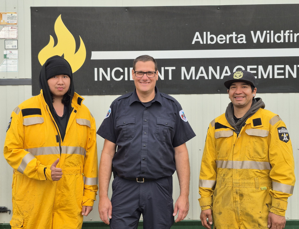 Members of the HWF036 supply team — Houston Yahkinneah of the Dene Tha, Meander River (left); Christian Boudreau with the Quebec incident management team (IMT); and Kurri Laboucan of the Little Red River Cree Nation (right) — are an essential part of the support provided to frontline personnel on this and other wildfires (June 16). A special thank-you to all our Indigenous firefighters and support personnel, and to the members of the Quebec IMT who are completing their assignment here in the High Level Forest Area today.
Wildfires north-northeast of LRRCN communities
Three very small wildfires (HWF054, HWF055 and HWF056) were detected late yesterday to the east-northeast of John D’Or and north-northeast of Fox Lake. Firefighters and airtankers responded quickly to these wildfires – and their efforts are ongoing. Currently, HWF055 is under control, and HWF054 and HWF056 are being held.
Smoke or fog from HWF040
HWF040, which is about 22 km east of the La Crete (Tompkins) Ferry and about 395 ha in size, remains under control. There is, however, an area of peat soil within the interior of this wildfire. Given the nature of peat and the likelihood of an inversion — a layer of warmer air covering a cooler one, reversing the normal temperature gradient where air cools with increasing altitude — residents and others in the area may see a fog or smoke in the vicinity. This is expected and does not indicate an increase in overall fire activity.
Smoke from wildfires on the Alberta-B.C. border
Residents and others on the western side of the forest area may see smoke from three wildfires (HBZ001, HBZ002 and HBZ003) currently burning along the provincial border. The High Level Fire Centre is in regular contact with its B.C. counterpart to monitor these wildfires and coordinate suppression activities. Alberta Wildfire airtankers have conducted some drops on HBZ001. Visit Fire Smoke Canada to see where smoke is coming from. If you have smoke-related health concerns, call 811 or visit Alberta Health.
Wildfire statistics
Since January 1, there have been 57 wildfires in the High Level Forest Area, burning a total of approximately 46,802 ha. To view wildfires on a map and for live updates, download the Alberta Wildfire App or visit the Alberta Wildfire Dashboard. Learn more about wildfire status definitions used in Alberta.
Fire ban
A fire ban remains in effect for the High Level Forest Area. Under this ban, all outdoor wood fires are prohibited, and existing fire permits are suspended.
Prohibited:
- All outdoor wood fires, including wood campfires on public and private land, designated firepits and backyard firepits
- Barbecue charcoal briquettes
- Fireworks and exploding targets
Allowed:
- Propane fire pits and natural gas-powered appliances
- Indoor wood fires
- Open flame oil devices
The fire ban will remain in effect until conditions improve. Visit Alberta Fire Bans for more information and to see the boundaries. See the fire ban fact sheet for more information.
Contact info
Mark Giles
780-285-4490
[email protected]
Published on June 17, 2025 3:13 pm