The fire danger remains extreme. Forest vegetation is extremely dry and poses a very serious fire risk. Fast-spreading, high-intensity fires are possible, which can make firefighting challenging.
Wildfire situation
Two smaller wildfires now under control, smoke from HWF040
HWF037 and HWF040 are both now under control, which means they are completely contained, and no additional growth is expected. HWF037 is located about 33 km west of Tall Cree First Nation South and estimated to be 1060 hectares (ha) in size. HWF040 is about 22 km east of the La Crete (Tompkins) Ferry and is about 395 ha. The causes of both remain under investigation.
There is an area of peat soil within the interior of HWF040. Given the nature of peat and the likelihood of an inversion — a layer of warmer air covering a cooler one, reversing the normal temperature gradient where air cools with increasing altitude — residents and others in the area may see a fog or smoke in the vicinity. This is expected and does not indicate an increase in overall fire activity.
Sousa Creek Wildfire (HWF036)
The Sousa Creek Wildfire is located between the towns of Rainbow Lake and High Level, near the Chateh turnoff, and along both sides of Highway 58. This wildfire is currently out of control and estimated to cover 42,412 ha. The cause of this wildfire is under investigation.
Yesterday saw some very limited growth along the southwest side. Today, there is no observable growth, although a small number of new hot spots have been noted within the perimeter over the past 24 hours. While the north and northeast sides will always be a priority given the proximity to Chateh, firefighters have also been focused on the southwest side to prevent growth in this direction.
Airtankers are being used as needed. Night-vision-equipped helicopters are also being employed on HWF036, when conditions permit, to assist with overnight operations.
HWF036 remains approximately:
- 5.3 km from the southern edge of the community (reserve area) of Chateh;
- 55 km from the southeast edge of the community (reserve area) of Meander River;
- 71 km from the western edge of the Town of High Level; and
- 27 km from the eastern edge of the Town of Rainbow Lake.
Given the efforts of firefighters, and old burns (previous wildfire areas) stalling growth towards some communities (e.g. east towards High Level), these distances have remained relatively the same in recent days.
Map of HWF036 (June 12, 2025)
Firefighters and heavy equipment operators, working closely with helicopters with water buckets, continue their perimeter work – securing and reinforcing containment lines surrounding the wildfire.
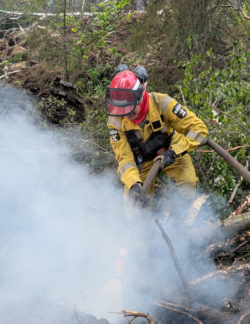 A firefighter with hose works to extinguish a hot spot on the perimeter of the Sousa Creek Wildfire (June 12)
Alberta Wildfire continues to work closely with Chateh community leaders and their emergency management team. Power to the Town of Rainbow Lake and Chateh is not currently impacted. ATCO crews continue working to repair damaged powerline infrastructure.
Posted speed and highway closures
Firefighters are asking members of the public to slow down near work areas. Please respect the 50 km/h signs for everyone’s safety. Expect delays or intermittent closures on Highway 58. Visit Alberta 511 for updates.
Smoke from wildfires on the Alberta-B.C. border
Residents and others on the western side of the forest area may see smoke from three wildfires (HBZ001, HBZ002 and HBZ003) currently burning along the provincial border. The High Level Fire Centre is in regular contact with its B.C. counterpart to monitor these wildfires.
Visit Fire Smoke Canada to see where smoke is coming from. If you have smoke-related health concerns, call 811 or visit Alberta Health.
Wildfire statistics
To view wildfires on a map and for live updates, download the Alberta Wildfire App or visit the Alberta Wildfire Dashboard. Learn more about wildfire status definitions used in Alberta.
Fire ban
A fire ban is in effect for the entire Forest Protection Area in Alberta. Under this ban, all outdoor wood fires are prohibited and existing fire permits are suspended.
Prohibited:
- All outdoor wood fires, including wood campfires on public and private land, designated firepits and backyard firepits
- Barbecue charcoal briquettes
- Fireworks and exploding targets
Allowed:
- Propane fire pits and natural gas-powered appliances
- Indoor wood fires
- Open flame oil devices
The fire ban will remain in effect until conditions improve. Visit Alberta Fire Bans for more information and to see the boundaries. See the fire ban fact sheet for more information.
Not worth the risk
Abiding by the rules related to fire in Alberta's Forest Protection Area (FPA) protects homes, lives, livelihoods and landscapes.
And not following the rules can lead to serious fines and penalties, including:
- Burning without a permit — $350
- Failure to extinguish permitted burn — $840
- Leaving a campfire unattended — $600
- Starting a fire during a fire ban — $600
- Setting off explosives/fireworks in the FPA — $600
- Operating an off-highway vehicle (OHV) during an OHV ban or forest closure — $1,200
- Interfering with wildfire operations — mandatory court appearance
Camping and recreating without a wood fire can be as easy as bringing along propane alternatives. Always check Alberta Fire Bans before heading out.
Unsure what activities are permitted in specific locations? Give us a call on our fire information line at 1-866-FYI-FIRE (394-3473). To report illegal fire activity call 310-FIRE (3473).
Contact info
Mark Giles
780-285-4490
[email protected]
Published on June 13, 2025 3:24 pm