The fire danger in the Grande Prairie Forest Area is moderate.
Cooler temperatures and recent rain have reduced the overall risk. However, wildfires can still start, especially in dry areas or during windy conditions, so it is important to continue using caution with outdoor fires and do your part to prevent wildfires.
Fire ban and restriction update
All fire restrictions within the Grande Prairie Forest Area have been lifted. However, as we remain in wildfire season, it's important to continue safe burning practices.
Fire restrictions can vary depending on your location. Forest areas, municipalities, and provincial parks may each have their own fire advisory, restriction, or ban. For example, the County and City of Grande Prairie currently have fire restrictions in place while the Grande Prairie Forest Area does not.
Conditions can vary between regions. Forested areas may retain more moisture than open grassy fields, leading to different fire danger levels and the need for area-specific restrictions.
To stay informed, visit Alberta Fire Bans. You can also download the Alberta Fire Bans app, which uses your location to show the most up-to-date information near you.
Wildfire situation
GWF028 - The Hamelin Creek wildfire near Moonshine Lake Provincial Park
This wildfire remains classified as out of control and is estimated at 5,557 hectares in size. Recent rainfall and cooler temperatures have improved conditions on the ground, allowing firefighters, heavy equipment, and helicopters to make steady progress in identifying and suppressing hot spots. While progress is being made, the fire remains active, and conditions will continue to be closely monitored.
Saddle Hills County evacuation order and alert
While this wildfire does not currently threaten any homes or structures, an evacuation order and alert are still in place. Moonshine Lake Provincial Park remains closed.
See Alberta Emergency Alert for evacuation zone information and further details.
You can also visit the Saddle Hills County webpage or Facebook page for more information.
GWF040 - Wildfire south of Grande Prairie
Alberta Wildfire continues to respond to this wildfire, located approximately 78 km south of Grande Prairie and 19 km east of Highway 40. The wildfire is estimated at 247 hectares in size and remains classified as out of control.
Steep terrain has made some areas difficult to access, but firefighting crews, heavy equipment, and helicopters remain actively engaged. Recent rainfall over the past few days has helped support firefighting efforts, slowing fire spread and improving firefighting operations. Firefighters continue to focus on strengthening containment lines and targeting hot spots.
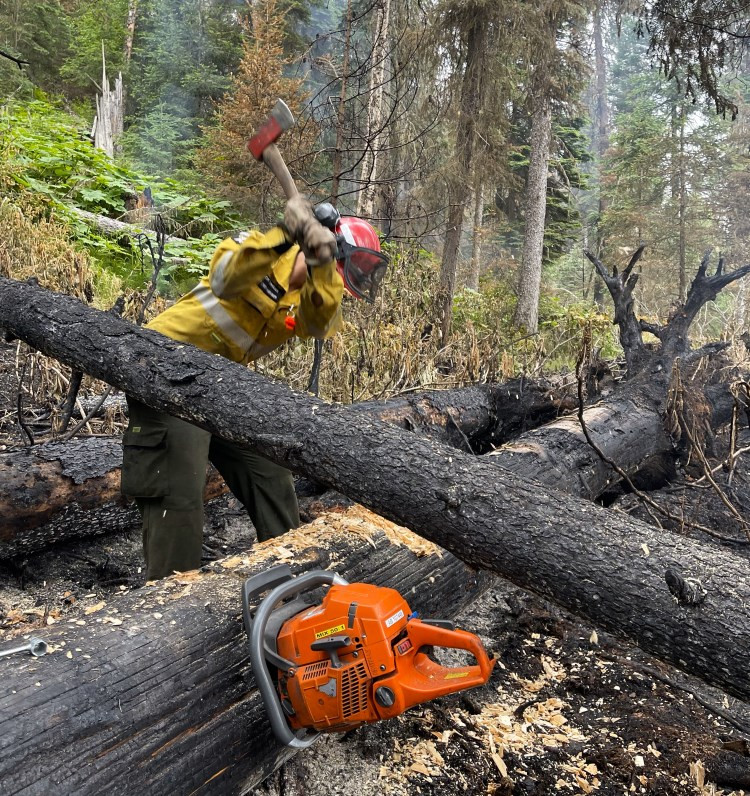 An Alberta wildland firefighter with the Grande Prairie Unit Crew works to extinguish a hot spot within wildfire GWF040. Photo taken on June 19.
GWF042, GWF043 and GWF045 - Quick response to lightning wildfires
Recent lightning activity south of Grande Prairie sparked multiple wildfires in the area. Thanks to quick detection by lookout tower observers, members of the public, and industry personnel, these wildfires were located early and responded to before they had a chance to grow.
GWF042 and GWF043 were extinguished on June 19. GWF045 is classified as being held and is approximately 0.01 hectares in size.
GBZ001 - Kiskatinaw River wildfire
Discovered on May 28, this wildfire originated in British Columbia is now classified as being held thanks to the recent rainfall, cooler temperatures and the hard work of firefighters. It is estimated at 26,315 hectares and is located near the Alberta–British Columbia border, approximately 68 km west of Grande Prairie.
The response to the Kiskatinaw wildfire has involved countless hours of effort from firefighters, support staff, heavy equipment operators, aircraft pilots, and local emergency management personnel. Their commitment and collaboration across provincial and municipal lines have been instrumental in slowing the spread of this wildfire and protecting nearby communities. Even with the fire now classified as being held, work continues—firefighters remain on the ground reinforcing containment lines, extinguishing hot spots, and monitoring conditions to ensure the fire stays within its perimeter.
The BC Wildfire Service is the primary agency in command of working to contain this wildfire. Alberta Wildfire is supporting these efforts as needed. The incident management team is also working closely with the County of Grande Prairie and the Peace River Regional District to ensure a coordinated regional response.
For more information on this wildfire and others in B.C., visit the BC Wildfire Service website.
Grande Prairie Forest Area statistics
Since January 1, there have been 45 wildfires in the Grande Prairie Forest Area, burning a total of 5,822 hectares.
Learn more about active wildfires, their locations and stats on the interactive map on our wildfire status page.
Lightning-caused wildfires
Lightning is typical this time of year and has been detected across our forest area, with the possibility of more throughout the weekend. This increases the potential for new wildfire starts. Lightning-caused wildfires can smoulder beneath the surface for several days before becoming active and visible when conditions are favourable, particularly during dry and windy weather.
If you see smoke or other signs of wildfire activity, report it immediately by calling 310-FIRE (3743). Early reporting helps firefighters respond more quickly and reduces the risk of wildfire spread.
Drones near wildfires
Flying a drone near or over a wildfire is dangerous and illegal. It endangers the lives of wildfire personnel and can force firefighting aircraft to be grounded, resulting in delays to critical wildfire suppression efforts. Operating a drone in these areas puts both people and aircraft at risk. Help keep our firefighters and air crews safe by giving them the space they need to do their jobs.
See Transport Canada for more information on drone regulations.
Contact info
Kassey Zatko
780-538-5327
[email protected]
Published on June 20, 2025 4:01 pm