The fire danger in the Grande Prairie Forest Area remains moderate.
Cooler temperatures and recent rain have lowered the overall wildfire risk. However, wildfires can still start, especially in dry areas and during windy conditions. Please continue to use caution with outdoor burning, as well as any work or recreational activities that could spark a wildfire.
Wildfire situation
For the most current information on active wildfires, including their locations and stats, visit our interactive wildfire map or download the AB Wildfire Status app.
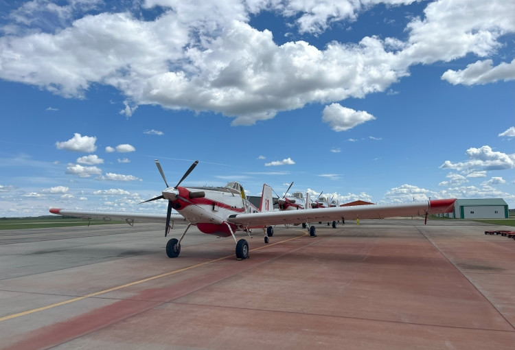 Four AT-802 Air Tractors at the Grande Prairie Air Tanker Base. These particular aircraft are part of Group 5, which initially responded to wildfire GWF-028. They are currently in Grande Prairie, ready to respond to any new wildfire starts. Each of these tankers can carry up to 3,000 liters of retardant and typically fly in groups of four when dispatched. These highly maneuverable, quick-to-load aircraft are a critical part of wildfire response. Photo: June 26.
Fire advisory
A fire advisory is in effect for the Grande Prairie Forest Area.
Under this advisory:
- Existing fire permits are valid. Remember fire permits are not valid in winds over 12 km/h.
- New fire permits will be issued on a case-by-case basis, for essential burning only.
- Any burning without a valid fire permit, other than a campfire is prohibited.
Farming and agricultural equipment
Agricultural equipment can inadvertently start a wildfire. If you are using farm equipment this wildfire season, take extra precautions by having firefighting equipment on hand. Read the FireSmart Farm and Acreage Guide to learn more about farm fire safety.
Contact info
Kassey Zatko
780-538-5327
[email protected]
Published on July 28, 2025 3:47 pm