The wildfire danger is very high in the Grande Prairie Forest Area. Warmer temperatures and strong, gusty winds have increased the danger level. These current conditions could lead to fast-moving wildfires.
If you're spending time or working outdoors, please use extra caution and stay informed.
Wildfire situation
For the most current information on active wildfires, including their locations and stats, visit our interactive wildfire map or download the AB Wildfire Status app.
GWF063 – Wildfire causes Two Lakes Road closure
Alberta Wildfire continues to respond to this wildfire located approximately 50 km southwest of Grande Prairie and 1 km north of the Two Lakes Road. Despite the distance, smoke from the fire has been visible from Grande Prairie. The wildfire is estimated at 25 hectares in size and remains classified as out of control.
Yesterday's strong, gusty winds increased fire intensity, causing the wildfire to grow quickly from 3 to 25 hectares. Today's forecast calls for continued wind, with even stronger wind speeds expected tomorrow.
Firefighters, airtankers, helicopters, and heavy equipment are actively responding. Firefighters must also take extra caution, as gusty winds can cause burned trees to fall in their work area.
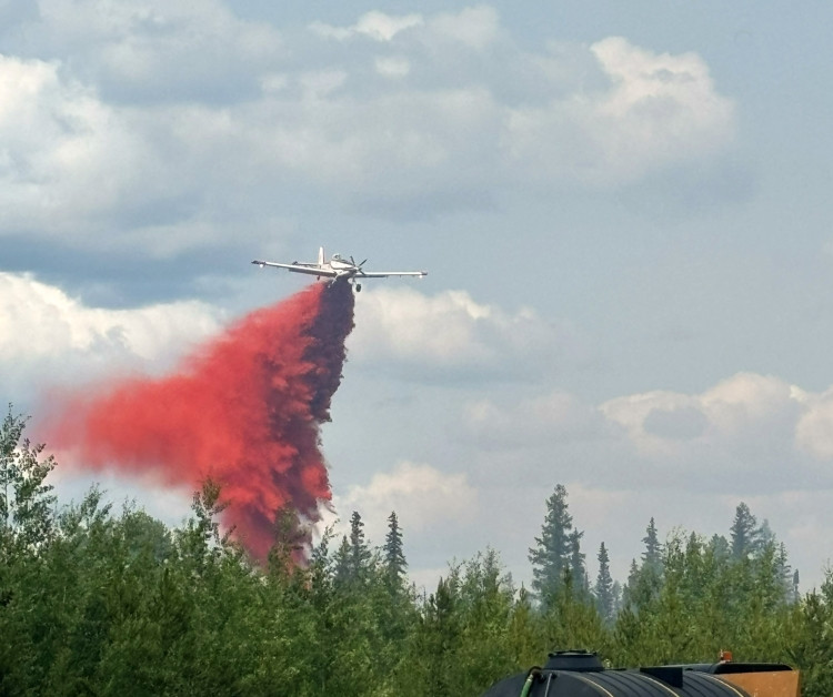 An AT-802 Air Tractor airtanker drops wildfire retardant over GWF063, located southwest of Grande Prairie. Airtankers play a key role in slowing wildfire spread and supporting firefighters. Photo: July 10.
Two Lakes Road - closed to public at kilometre 2-65
The M.D. of Greenview has closed the Two Lakes Road at kilometre 2-65 due to wildfire activity. Members of the public are asked to avoid the area for safety and to give firefighting crews the space they need to work.
Industry traffic is currently being allowed through security checkpoints; however, this may change depending on fire activity. Traffic exiting the Two Lakes area and heading north is being permitted through the checkpoints, but this remains a dynamic situation and conditions may change quickly.
For the latest road updates, please visit the M.D. of Greenview webpage.
Two Lakes Provincial Park - remains open
Although there is currently no access via the Two Lakes Road, the Two Lakes Provincial Park remains open. There is currently no wildfire risk to this area.
For information on this park, please visit the Alberta Parks website.
GWF028 - The Hamelin Creek wildfire
The Hamelin Creek wildfire, located near Moonshine Lake Provincial Park, remains classified as being held. It is estimated at 5,557 hectares in size. Firefighters, supported by heavy equipment and helicopters, continue to make steady progress by strengthening containment lines and extinguishing hot spots.
Dry conditions in the area are adding to the challenge, as the wildfire is burning deep underground. The cause has been determined to be lightning.
For municipality-related updates, visit the Saddle Hills County website.
Moonshine Lake Provincial Park
The Moonshine Lake Provincial Park is open to the public, but please note that some walking trails are closed.
For the most up to date information, please see the Alberta Parks website.
GBZ001 - Kiskatinaw River wildfire
The Kiskatinaw River wildfire, which started in British Columbia on May 28, remains classified as being held. It is estimated at 26,277 hectares in size and is located near the Alberta–British Columbia border, about 68 km west of Grande Prairie.
Unburned vegetation within the fire perimeter may ignite, and smoke could be visible in the area. Firefighting operations continue.
The BC Wildfire Service is leading the response to this wildfire, with Alberta Wildfire providing support as needed.
Please be aware that BC Wildfire Service has implemented an Area Restriction Order that limits access to some areas on the B.C. side of the boarder. For more information on this wildfire and others in B.C., visit the BC Wildfire Service website.
Grande Prairie Forest Area statistics
Since January 1, there have been 65 wildfires in the Grande Prairie Forest Area, burning a total of 5,848 hectares.
Fire advisory
A fire advisory is in effect for the Grande Prairie Forest Area, due to strong winds.
Under this advisory:
- Existing fire permits are valid. Remember fire permits are not valid in winds over 12km/h.
- New fire permits will be issued on a case-by-case basis, for essential burning only.
- Any burning without a valid fire permit, other than a campfire is prohibited.
Fire permits required
During wildfire season, a fire permit is required in the Forest Protection Area for all burning except campfires. Permits help us track where burning projects are happening and outline the conditions for a safe burn. Request your free fire permit online.
Contact info
Kassey Zatko
780-538-5327
[email protected]
Published on July 10, 2025 10:45 am