The wildfire danger is high in the Grande Prairie Forest Area. While parts of our Forest Area recently received rain, warmer temperatures have increased the danger level, and current conditions could lead to fast-moving wildfires.
A severe thunderstorm watch is also in effect for our area. Lightning and strong winds can start new wildfires and cause existing ones to spread quickly.
Wildfire situation
For the most current information on active wildfires, including their locations and stats, visit our interactive wildfire map or download the AB Wildfire Status app.
GWF094 - Lightning-caused wildfire
Wildfire GWF094 was reported yesterday evening around 8 pm through the 310-FIRE line by a member of the public. Firefighters responded quickly and located a small burning area, approximately 0.01 hectares in size, near a tree with clear signs of a recent lightning strike. The tree had a thick, spiraling crack down its side. With support from a bucketing helicopter, firefighters successfully extinguished the wildfire. This was located approximately 53 km south of Grande Prairie and 0.3 km west of Highway 40.
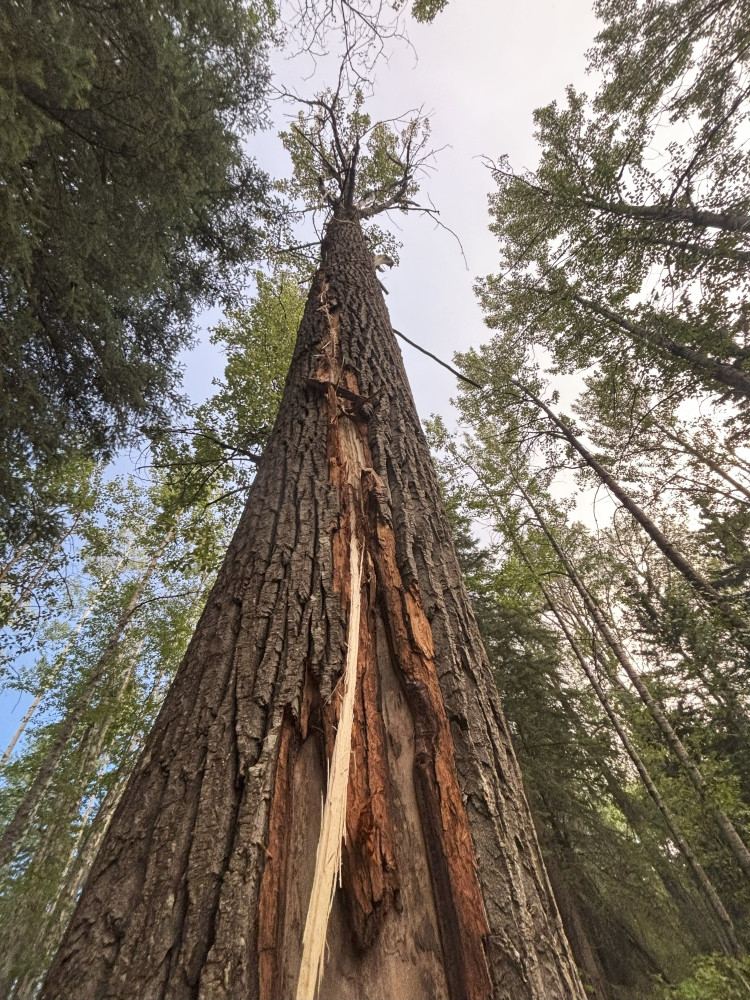 A tree with bark stripped in a spiraling vertical line, showing visible damage from a recent lightning strike on wildfire GWF094. Lightning can travel through trees and ignite vegetation on the forest floor. Photo: Aug. 5.
GWF093 - Now being held
Alberta Wildfire continues to respond to this wildfire, which is now classified as being held and estimated at 4 ha in size. The cause of GWF093 was determined to be lightning.
GBZ001 - Kiskatinaw River wildfire
The Kiskatinaw River wildfire, which started in British Columbia on May 28, remains classified as being held. It is estimated at 26,277 ha in size and is located near the Alberta–British Columbia border, approximately 68 km west of Grande Prairie. This wildfire was caused by lightning.
Unburnt fuels within the wildfire perimeter may continue to ignite and produce smoke. This area remains hazardous, with active fire, falling trees, smoke and unstable ground posing serious safety risks. Even areas that appear quiet can quickly become dangerous if wind conditions change or fire activity increases.
Please be aware that BC Wildfire Service has an Area Restriction in place that limits access to some areas on the B.C. side of the boarder.
The BC Wildfire Service is leading the response to this wildfire, with Alberta Wildfire providing support as needed.
For more information on this wildfire and others in B.C., visit the BC Wildfire Service website.
Grande Prairie Forest Area statistics
Since January 1, there have been 94 wildfires in the Grande Prairie Forest Area, burning a total of 5,884 ha.
Fire advisory
A fire advisory is in effect for the Grande Prairie Forest Area.
Under this advisory:
- Existing fire permits are valid. Remember fire permits are not valid in winds over 12 km/h.
- New fire permits will be issued on a case-by-case basis, for essential burning only.
- Any burning without a valid fire permit, other than a campfire is prohibited.
Lightning-caused wildfires
Lightning is typical this time of year and has been detected across the forest area, with more expected throughout the week. This increases the potential for new wildfire starts. Lightning-caused wildfires can smoulder beneath the surface for several days before becoming active and visible when conditions are favourable, particularly during dry and windy weather.
If you see smoke or other signs of wildfire activity, report it immediately by calling 310-FIRE(3743). Early reporting helps firefighters respond more quickly and reduces the risk of wildfire spread.
Contact info
Kassey Zatko
780-538-5327
[email protected]
Published on August 6, 2025 3:30 pm