The fire danger remains extreme. The forest vegetation is extremely dry and pose a very serious fire risk. Fast-spreading, high-intensity fires are likely, which will make firefighting challenging.
We urge residents, members of the public and industry to use extreme caution until conditions improve. Plan any activities that could create a spark, hot exhaust or friction late in the evening or early in the morning. Keep watch of your surroundings and carry sufficient firefighting equipment and water if you are working outdoors.
Wildfire situation
Since January 1, there have been 45 wildfires in the Edson Forest Area burning a total of 1,086 hectares (ha).
View active wildfires, their locations and statistics on the wildfire status dashboard. Wildfires are regularly assessed by experts and assigned a status to describe the behaviour of the wildfire, and how it is responding to suppression efforts under current and expected conditions.
EWF038 near Cynthia
EWF038 is located 12 km northeast of Cynthia and 10 km east of Highway 753. It is 7 km north of Highway 621, on the northeast corner of Sink Hole Lake. The wildfire is estimated to be 10 ha and classified as under control and not expected to grow. Firefighters continue searching for and extinguishing hot spots.
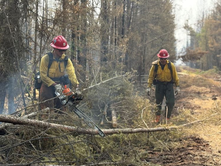
Yellowhead Wildfire Complex | EWF030, EWF036
EWF036 January Creek Wildfire
EWF036 is located on the south side of Peers on both sides of Highway 32. The size is estimated to be 738 ha and remains classified as out of control. The cause of the wildfire is under investigation.
Today, the area experienced moderate fire activity. Helicopters with water buckets assisted the firefighters on the ground with hot spots. No airtankers were required. Tomorrow, a high of 12C and relative humidity of 65% is in the forecast, with winds from the east at 25 km/h, gusting to 45 km/h. Some rain is forecasted for tonight and significant rain in the forecast for tomorrow.
The wildfire did not burn all the vegetation within the wildfire perimeter. As conditions continue to dry and winds encourage the hot spots to ignite larger vegetation, smoke will be visible from within the fire perimeter. This is expected to happen and firefighters are on scene if the wildfire escapes the fire perimeter to prevent the spread.
Firefighters have been working tirelessly over the past several week to contain the wildfire as quickly and safely as possible. Their efforts have included long hours on the fire line, often in challenging conditions, to bring the wildfire to extinguishment. They will continue to be supported by heavy equipment and helicopters, searching for and extinguishing hot spots on the wildfire. A fire crew from California joined Alberta Wildfire and Yellowhead County Fire Department yesterday on the fire line.
Aerial heat scans identified priority hot spots last night, with most heat located in the interior of the wildfire perimeter. Crews are headed to the new areas to focus their efforts on these zones. Additional heat scans are planned in the coming days to guide ongoing work.
 Firefighters from California join our Alberta Wildfire and Yellowhead County Fire Department firefighters on the line yesterday (June 10, 2025).
EWF030 Mercoal Creek Wildfire
EWF030 is located 6 km west of Mercoal and 16 km southwest of Robb. The wildfire is estimated to be 320 ha in size and determined to be caused by lightning. The wildfire is now classified as under control which means that firefighting efforts were successful and there is no risk that the fire will spread. No hot spots were found during the last aerial heat scan, firefighters will monitor regularly for any activity and action the fire if there is any.
Reclamation of containment lines that were created by heavy equipment has begun on EWF030. These areas are restored to a more natural state, encouraging new vegetation growth, reducing environmental impacts, and preventing erosion.
Smoky conditions
Smoke from surrounding fires may be visible and settling over our communities. Visit firesmoke.ca to see where the smoke is coming from. If you have smoke-related health concerns, call 811 or visit the Alberta Health website.
Evacuations and road closures
Visit Alberta Emergency Alert or download the app for information on current evacuation orders or alerts. You can also find information on wildfire preparedness on our website. For highway closures, visit Alberta 511.
Fire ban
A fire ban is in effect for the entire Forest Protection Area in Alberta. Under this ban, all outdoor wood fires are prohibited and existing fire permits are suspended.
Prohibited:
- All outdoor wood fires, including wood campfires on public and private land, designated firepits and backyard firepits
- Barbecue charcoal briquettes
- Fireworks and exploding targets
Allowed:
- Propane fire pits and natural gas-powered appliances
- Indoor wood fires
- Open flame oil devices
The fire ban will remain in effect until conditions improve. Visit Alberta Fire Bans for more information and to see the boundaries. See the fire ban fact sheet for more information.
Contact info
Caroline Charbonneau
780-740-1341
[email protected]
Published on June 11, 2025 8:18 pm