The fire danger remains extreme. The forest vegetation is extremely dry and pose a very serious fire risk. Fast-spreading, high-intensity fires are likely, which will make firefighting challenging.
We urge residents, members of the public and industry to use extreme caution until conditions improve. Wildfires are most active between 11 am and 9 pm. Plan any activities that could create a spark, hot exhaust or friction late in the evening or early in the morning. Keep watch of your surroundings and carry sufficient firefighting equipment and water if you are working outdoors.
Wildfire situation
Since January 1, there have been 45 wildfires in the Edson Forest Area burning a total of 1,086 hectares (ha).
View active wildfires, their locations and statistics on the interactive map on our wildfire status page. Wildfires are regularly assessed by experts and assigned a status to describe the behaviour of the wildfire, and how it is responding to suppression efforts under current and expected conditions. Visit our website to learn more.
The area is detecting powerline caused wildfires
Windy conditions can knock down trees onto powerlines and cause wildfires. The forest area has firefighters and equipment ready to respond for the increase in fire danger and new wildfire starts.
Call 310-FIRE if you see smoke or flames and suspect it's a wildfire. Learn more about how to report a wildfire. The sooner you report it, the quicker our crews can respond.
EWF045 north of Bickerdike
Firefighters and helicopters are currently responding to a wildfire located north of Highway 16 near Bickerdike on Range Road 185, 11 km west of Edson. It's estimated to be 0.32 ha in size and being held and not expected to grow beyond its existing boundaries, given current weather conditions and resources. Firefighters were able to quickly respond thanks to a near by resident who called in early this morning. Crews were able to knock down the flame and are searching for and extinguishing hot spots in the ground to ensure it's fully extinguished.
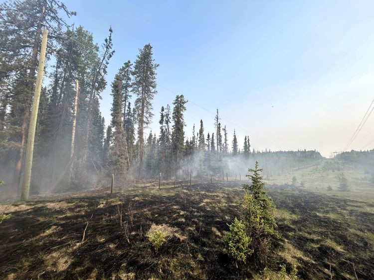 EWF045 is now being held along a powerline right of way north of Bikerdike (June 7, 2025 at 8:00 am)
Yellowhead Wildfire Complex | EWF030, EWF036, EWF038
EWF038 near Cynthia
EWF038 is located 12 km northeast of Cynthia and 10 km east of Highway 753. It is 7 km north of Highway 621, on the northeast corner of Sink Hole Lake. The wildfire is estimated to be 10 ha and classified as under control. Firefighter efforts have been successful and we don't expect this fire to grow. They continue searching for and extinguishing hot spots.
EWF036 January Creek Wildfire
EWF036 is located on the south side of Peers. The size is estimated to be 738 ha and remains classified as out of control which means that the wildfire has the potential to grow. A status change will only occur when firefighters are confident there is no risk for further growth. The cause of the wildfire is under investigation.
In order to allow residents to return to their homes, firefighters focused on the areas of the wildfire closest to the community. They built containment lines with heavy equipment on the north side of the wildfire. Firefighters searched for and extinguished hot spots in these areas to prevent any flare ups near Peers.
Firefighters continue to work along and within the perimeter, securing and re-enforcing the containment lines surrounding the wildfire. This process, called mop up, can take several days and sometimes weeks, depending on how many hot spots are found and how deeply they are burning in the ground.
Aerial heat scanning was conducted and crews are working on priority hot spots. The majority of the heat was located in the interior of the wildfire perimeter on the northeast and southwest of the wildfire. Another heat scan is scheduled in the following days to help focus firefighting efforts.
Firefighters observed increased wildfire activity because of higher temperatures, low humidity and strong gusting winds yesterday. Airtankers were dispatched to assist on the northeast corner to cool the flare-up, skimming on Shinning bank Lake. They are available again if required. Firefighters will be on scene and ready to respond if an increase in fire behaviour does occur. Smoke will be visible from within the fire perimeter.
Today, similar conditions are expected with a high of 20C, relative humidity of 25% and winds northwest 20-25 gusting to 50 km/h. This could move wildfires towards the southeast. No precipitation is in the short-term forecast.
EWF030 Mercoal Creek Wildfire
EWF030 is located 6 km west of Mercoal and 16 km southwest of Robb. The wildfire is now classified as being held which means that given current weather conditions and resources, the wildfire is not anticipated to grow past existing boundaries. The wildfire is estimated to be 320 ha in size and determined to be caused by lightning.
Aerial heat scans were conducted and it identified very little heat. Firefighters continue extinguishing hot spots, which involves digging deep into the ground and dousing the smouldering fire with water. They'll continue this work until the hot spots are extinguished.
Smoky conditions
Smoke from surrounding fires may be visible and settling over our communities. Visit firesmoke.ca to see where the smoke is coming from. If you have smoke-related health concerns, call 811 or visit the Alberta Health website.
Evacuations and road closures
Visit Alberta Emergency Alert or download the app for information on current evacuation orders or alerts. You can also find information on wildfire preparedness on our website. For highway closures, visit Alberta 511.
Safety near burnt areas
We urge residents and members of the public to use extra caution near burnt areas. There are many hazards that may not be visible, like deep burning ash pits and falling trees. Burnt trees are a serious hazard, and trees that may look healthy that have green needles or leaves could have burnt out roots under the ground and fall unexpectedly. Keep in mind that trees and powerlines could also fall on the road and block your vehicle. Do not approach powerlines as they could be energized.
Fire ban
A fire ban is in effect for the entire Forest Protection Area in Alberta. Under this ban, all outdoor wood fires are prohibited and existing fire permits are suspended.
Prohibited:
- All outdoor wood fires, including wood campfires on public and private land, designated firepits and backyard firepits
- Barbecue charcoal briquettes
- Fireworks and exploding targets
Allowed:
- Propane fire pits and natural gas-powered appliances
- Indoor wood fires
- Open flame oil devices
The fire ban will remain in effect until conditions improve. Visit Alberta Fire Bans for more information and to see the boundaries. See the fire ban fact sheet for more information.
Contact info
Caroline Charbonneau
780-740-1341
[email protected]
Published on June 7, 2025 11:21 am