The wildfire danger in the Edson Forest Area remains moderate. Wildfires can start and spread but are less likely to become severe if detected and responded to quickly. Recent rainfall has added some moisture to vegetation, however, debris on the forest floor can still dry out quickly in the afternoon heat. Please continue to be cautious when working or spending time outdoors.
Wildfire situation
Since January 1, there have been 68 wildfires in the Edson Forest Area burning a total of 1,089 hectares (ha). View active wildfires, their locations and statistics on the wildfire status dashboard. Wildfires are regularly assessed by experts and assigned a status to describe the behaviour of the wildfire and how it is responding to suppression efforts under current and expected conditions.
Wildfire near Emerson Lake (EWF068)
EWF068 was detected this afternoon. The wildfire is currently classified as out of control and estimated to be 0.5 ha in size. The wildfire is located 8 km northwest of Emerson Lake, along the Athabasca River. Firefighters, heavy equipment and airtankers are currently on scene. The cause of the wildfire is under investigation. There is no threat to any communities at this time.
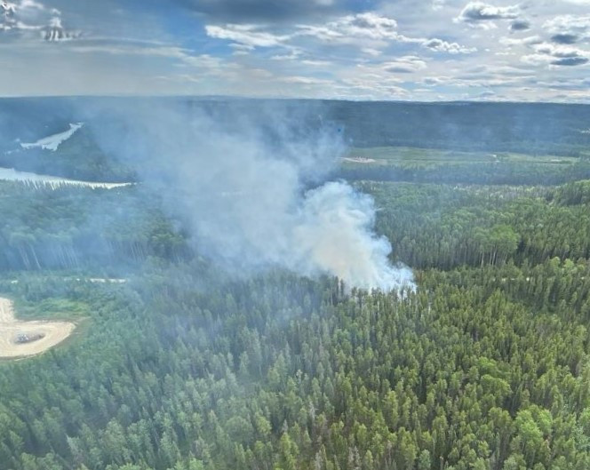 An aerial view of wildfire EWF068, taken at 16:30 on July 11, 2025.
Wildfire near Marlboro (EWF067)
EWF067 was detected this afternoon. The wildfire is currently classified as out of control and estimated to be 2.5 ha in size. The wildfire is located 2.5 km north of Highway 16, 2 km northwest of Marlboro and 23 km west of Edson. Firefighters, heavy equipment and airtankers are currently on scene with Yellowhead County Fire Deptarment firefighters. There is no threat to any communities at this time.
Sink Hole Wildfire (EWF038)
EWF038 is located 12 km northeast of Cynthia and 10 km east of Highway 753. It is 7 km north of Highway 621 on the northeast corner of Sink Hole Lake. The wildfire is estimated to be 10 ha and is classified as under control. The wildfire was determined to be caused by lightning. Firefighters will monitor this wildfire for activity and respond if required.
January Creek Wildfire (EWF036)
EWF036 is part of the Yellowhead Wildfire Complex and located on the south side of Peers, on both sides of Highway 32. The size is estimated to be 738 ha and it is classified as under control. Firefighters will monitor this wildfire for activity and respond if required. The cause remains under investigation.
Mercoal Creek Wildfire (EWF030)
EWF030 is part of the Yellowhead Wildfire Complex and is located 6 km west of Mercoal and 16 km southwest of Robb. The wildfire is estimated to be 320 ha in size and is classified as under control. The wildfire was determined to be caused by lightning. Firefighters will monitor this wildfire for activity and respond if required.
Lightning
Lightning-caused wildfires are common this time of year. These wildfires can smoulder beneath the surface for several days before becoming active and visible, especially during dry and windy conditions. If you see smoke or other signs of wildfire activity, report it immediately by calling 310-FIRE (3743).
Fully extinguish your campfires
If you're out in the forested areas we ask that you fully extinguish campfires after you're finished. While some areas may have received rain, a campfire can spread into the ground and lay idle until conditions improve. When hot and windy conditions occur your abandoned campfire can quickly turn into a wildfire as embers can travel into nearby vegetation. Always remember to fully extinguish your campfire by soaking it, stirring it, and soaking it again.
Contact info
Terry Abual-Soud
780-728-2397
[email protected]
Published on July 11, 2025 7:53 pm