
Wetlands have gained increased recognition in recent decades for their importance in capturing and storing carbon, mitigating the impacts of extreme weather such as floods and drought, purifying our water and offering immense benefits for biodiversity. Wetlands support 40% of the world’s plants and animals while covering only 6% of the planet. They play a vital role in sustaining our environment.
Amanda Cooper, Wetlands Team Lead with Alberta Environment and Protected Areas (EPA), has spent her career working with Alberta’s wetlands. From surveying wetlands on the ground to implementing the Alberta Wetland Policy, Amanda has experienced how critical accurate wetland mapping data is to making informed planning and management decisions. “One of the biggest gaps in wetland management in Alberta is an accurate understanding of where the wetlands are on the landscape,” explains Amanda.
Developing an accurate, provincewide wetland inventory is challenging due to the diversity of Alberta’s landscape and wetland ecosystems. However, airplanes and satellites equipped with imaging sensors, also known as remote sensing, can cover large areas. This provides a relatively low-cost method of mapping the Earth’s surface and its features at a very high resolution. While these data are becoming more readily available, it is not the only aspect required to advance a wetland inventory. Advancements in artificial intelligence (AI) and machine learning are opening opportunities to better use remote sensing data to develop innovative, highly accurate mapping products across large, diverse landscapes and Alberta is at the forefront.
Unique ecosystems
In Alberta, wetlands cover approximately 28% of the province’s land area and is home to 3 world-recognized Ramsar wetlands – the Beaverhill Biosphere, Hay-Zama Lakes and the Peace Athabasca Delta. These wetlands support numerous plants and animals including species at risk.
Wetlands come in all shapes and sizes. In Alberta’s grassland region, shallow open water wetlands and marshes, commonly referred to as potholes, are common. These wetland types provide some of the best waterfowl breeding habitat in the world. As you look north to Alberta’s boreal region, peatlands become more common. Surface water in these wetlands may not be visible and trees such as black spruce and tamarack may be present, often with mats of mosses below. Peatlands provide habitat for woodland caribou and many other species; they also store more carbon than all the world’s forest biomass combined. These wetlands help maintain and regulate both surface and groundwater across the landscape.
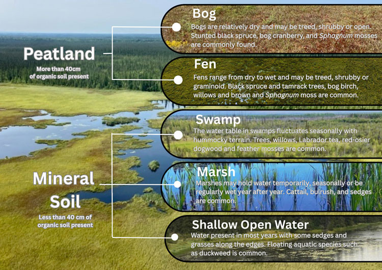
The wetland diversity found in the province is described in the Alberta Wetland Classification System which characterizes wetlands based on their soil, vegetation and water properties. This system classifies Alberta’s wetlands into 5 classes including bog, fen, swamp, marsh and shallow open water wetland (Figure 1).
Figure 1. Wetland classes in Alberta based on the Alberta Wetland Classification System
Challenges of this landscape
Alberta’s expansive and diverse landscapes create challenges in developing a provincial wetland inventory. In the grassland region, snow and rain events cause wetland water levels to fluctuate significantly between seasons and years. This makes it tricky to map these wetlands as the presence or absence of water alone cannot be used to identify or delineate them. Meanwhile, in the forested part of the province, wetlands may be dominated by water tolerant trees (for example, black spruce and tamarack) which can be hard to distinguish from upland forests.
Today, Alberta relies on the Alberta Merged Wetland Inventory (AMWI), a mosaic created by stitching together several regional wetland inventories to develop a provincial wetland inventory. Industry, stakeholders and government staff face some challenges utilizing this inventory given its components were completed at different times with varying methodologies that each come with differing limitations and accuracy. While the AMWI remains an important and impressive mapping product, its utility in site-level planning and even broader landscape-level planning can be limited, particularly if the base imagery is a decade or more old.
“Right now, we have an idea of where many wetlands are, but it’s not as accurate as we need,” notes Amanda. “We need a higher resolution, up-to-date and consistent wetland inventory to better inform site-level and landscape-level planning, to track wetland impacts and loss, and to help us identify where we may need to implement improved wetland conservation tools.”
Innovative approaches to mapping
In an effort to promote consistency and improve data quality at a provincial scale, EPA released the Alberta Wetland Mapping Standards and Guidelines in 2020. These standards and guidelines define important aspects of wetland mapping such as the expected minimum mapping unit and classification accuracy.
In collaboration with the Alberta Biodiversity Monitoring Institute (ABMI) and Ducks Unlimited Canada (DUC), EPA recently completed a project to test new automated approaches to wetland mapping and to examine whether these techniques could achieve the province’s wetland mapping standards. The project, funded by EPA’s Wetland Replacement Program, mapped 4 areas across the province including 2 sites in the Boreal region, one area in the Parkland region and one area in the Grassland region.
This test project took advantage of the unique strengths of different data sources and combined multiple streams of remote sensing data such as high-resolution satellite imagery, Synthetic Aperture Radar (SAR) and Light Detection and Ranging (LiDAR) data. LiDAR is particularly important as it provides 3-dimensional structure of the landscape and can be used to produce high resolution images of topography, as well as provide information on vegetation height and composition. Using these data, the project team tested the model’s abilities to accurately delineate and classify wetlands when combined with different AI processes including machine learning and deep learning.
Machine learning works by using algorithms to identify patterns in structured data, such as identifying features that make up specific wetland classes and then uses this information to make decisions and predictions of where wetlands occur across the broader landscape. Deep learning takes the machine learning approach a step further. Instead of identifying patterns in only the structured data, the algorithms create artificial neural networks, similar to how our brains work, to learn from its surroundings by assessing unstructured data (data that has no fixed framework such as imagery, documents, raw data etc.). This technique is computationally intensive as it continues to learn and improve as more information is gathered.
Project success
This project successfully demonstrated how a combination of machine learning and deep learning approaches were able to meet the Alberta Wetland Mapping Accuracy Standards in the Grassland and Boreal regions.
“By harnessing the latest innovations in AI and Earth observation technologies, our team pushed the boundaries of automated wetland detection and revealed new insights into wetland ecosystem distributions across Alberta” explains Michael Merchant, senior Earth observation data scientist with ABMI.
While the automated methodology resulted in a slightly lower accuracy rate in classifying wetlands in the Parkland region, the project team is optimistic this could be improved moving forward with the learnings from this project and further refinements to the wetland modelling approaches.
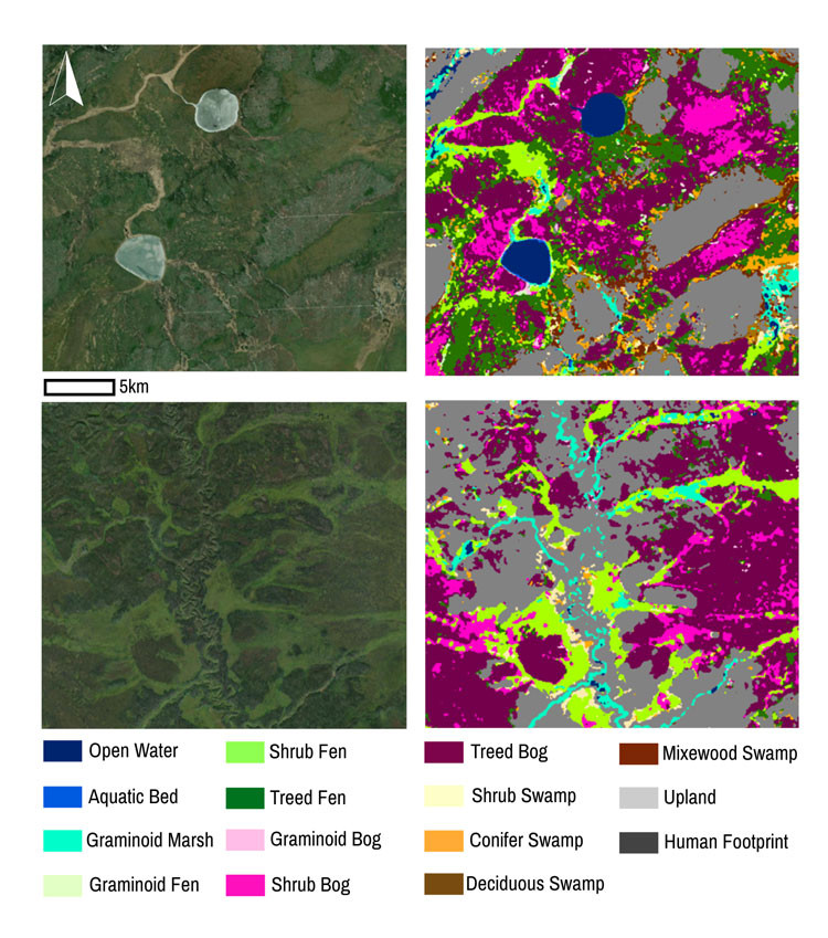
“Mapping wetlands across this diverse landscape is challenging, but this project has showcased that using AI can help us do this in a consistent, high quality and repeatable way” concludes Becky Edwards, advanced remote sensing analyst with DUC (Figure 2).
Figure 2. Satellite view of a boreal landscape on the left compared to a wetland map of the same area developed under the pilot project
The success of this project and its innovative approaches were further highlighted and explored at the Wetland Inventory Science Workshop hosted by the Office of the Chief Scientist in 2024. With remote sensing and AI technology continually improving, there are incredible advancements happening across North America and this workshop provided an opportunity for experts to share and learn from each other.
“Alberta is at the forefront of modern wetland mapping and this project has shown that it is possible to accurately map and classify wetlands through new and innovative approaches,” concludes Amanda. With these new tools and updated imagery, Alberta is well on the way to producing a provincial wetland inventory that will meet the needs of diverse stakeholders.
Resources
-

Dr. Jonathan Thompson
Dr. Jonathan Thompson was appointed as Environment and Protected Areas’ Chief Scientist on October 13, 2020.