
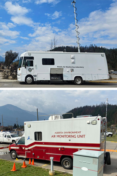
During the devastating wildfire in Jasper, Alberta, in the summer of 2024, a team from Alberta Environment and Protected Areas (EPA) deployed 2 high-tech mobile air quality monitoring labs as well as 5 portable sensors to the area. With this monitoring in place, first responders and residents had accurate, up-to-date information about air quality right there.
Providing real time data is just one of many important duties carried out by the Provincial Air Monitoring Team, led by senior manager Marty Collins. Marty has been involved with air monitoring for 19 years, 12 of which have been with the Government of Alberta.
Marty and his team of 6 air monitoring technologists, based in Edmonton and Calgary, respond to calls to monitor air quality across the province year-round. Unsurprisingly, their busiest time of year is typically wildfire season, which runs from March 1 to October 31 in Alberta.
“I feel very fortunate to have such an incredible team that works well together and supports each other,” said Marty.
Partners in understanding Alberta’s air quality
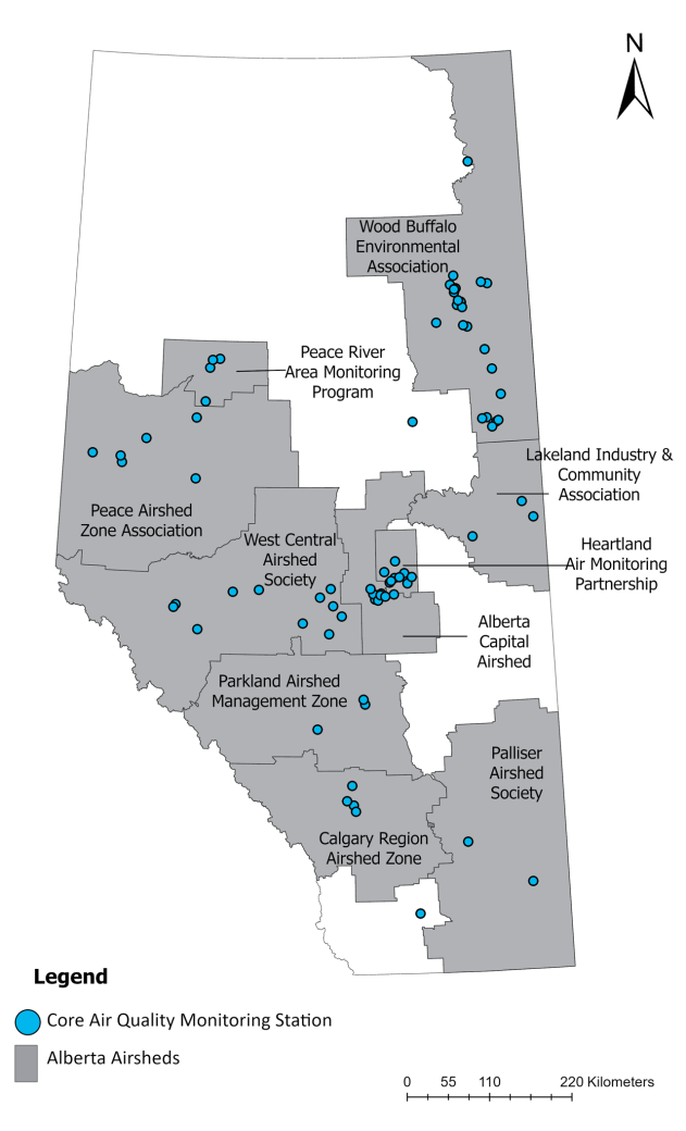
Alberta monitors air quality 24 hours a day, 7 days a week through a province-wide network of more than 70 permanent stations. These monitoring stations are primarily deployed within or near communities and continuously monitor for many key air quality parameters such as fine particulate matter, nitrogen dioxide and ozone. Data from this monitoring network informs the Air Quality Health Index, which reports current air quality results to the public.
EPA is directly responsible for 20 long-term air monitoring stations, while the rest are operated by local airshed organizations that share their data with the network.
“Depending on the geographical location, we partner with airshed organizations across Alberta to operate stations on our behalf and submit the data,” Marty explains. “These partnerships are critical to the success of our monitoring network.”
Alberta’s monitoring network also contributes data to the National Air Pollution Surveillance (NAPS) Program, a collaboration between various levels of government.
Responding to air quality emergencies
During emergencies, such as wildfires, Alberta increases air monitoring efforts with additional mobile systems. These can be deployed on short notice to provide data for areas of the province needing more than what is already covered with the long-term air monitoring stations.
Marty and his team operate 2 mobile air quality monitoring laboratories: the Mobile Air Monitoring Lab, an 8-metre-long retrofitted RV, and the Southern Alberta Air Monitoring Lab, built on a frame like an ambulance. Both labs are equipped with a variety of air sampling instruments, computer systems and GPS designed to measure and report on air quality quickly and reliably. The labs are winterized and used year-round to provide data for Alberta’s provincial air monitoring program.
As wildfire season approaches each year, Marty and his team make sure both the Mobile Air Monitoring Lab and Southern Alberta Air Monitoring Lab are up to date on maintenance, repairs and calibrations, and are ready to be deployed at a moment’s notice.
Emergency response requests can come in a few different ways. The team works closely with EPA’s Airshed Sciences Team, the Alberta Support and Emergency Response Team (ASERT), as well as officials from Alberta Health, local municipalities, emergency services teams, fire departments and police in affected areas. In the case of large-scale emergencies like the Jasper fire, the team coordinates with ASERT and the Provincial Emergency Coordination Center.
When the call comes in, the team deploys the Mobile Air Monitoring Lab, Southern Alberta Air Monitoring Lab, or both mobile labs and portable sensors to areas that lack or are not adequately covered by permanent monitoring stations. The team’s most important consideration when deploying sensors is staying out of harm's way.
“We work closely with the Provincial Emergency Coordination Center and teams on the ground to make sure it’s safe for our teams to deploy sensors,” said Marty, who added the team hasn’t lost any equipment to fire to date.
These sensors are especially important to first responders deploying to the fire zones. They let crews know what type of protective equipment to use and provide officials with information about air quality conditions that can be relayed to the public.
Increased demand, increased reporting
The demand for monitoring wildfire smoke and more localized air quality has been trending upward in recent years.
“There's an increased awareness about the importance of air quality data, both internally and with the public,” Marty says. “We’re seeing more and more requests to monitor air quality in areas where data is limited.”
The 2023 wildfire season was unprecedented in Alberta and across Canada with more fires and more area burned than ever recorded before. That year, Marty’s team deployed portable sensors and monitors across a large portion of northwest and north-central Alberta. In 2024, their most significant deployment was in Jasper.
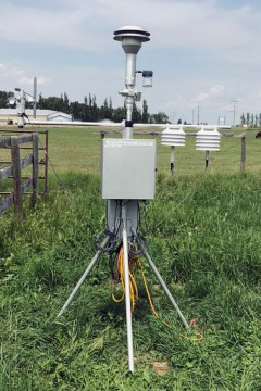
One type of portable equipment is called an Environmental Beta Attenuation Mass (E-BAM) monitor, that is easy to transport and can be deployed quickly. E-BAM monitors measure fine particulate matter that's 2.5 micrometers or smaller in size (PM2.5). PM2.5is the main parameter of concern for human health during wildfire season because it can work its way deep into lungs, causing long-term health concerns. Over the last 8 years, the team has been able to increase the number of portable E-BAM monitors available for mobile deployment from 6 to 16 units. In addition, the government’s 2025 budget has committed $1.6 million to building a new mobile monitoring lab to replace the current Mobile Air Monitoring Lab that is reaching the end of its life.
As data from portable monitors becomes available, EPA’s Airshed Sciences Team has also pioneered new ways to make this information accessible to the public. In 2024, the team shared data from 5 E-BAMs deployed in Jasper and Whitecourt on alberta.ca for the first time.
“It was a team effort between Airshed Sciences, the Air Monitoring team and Communications that allowed us to share the E-BAM data and support re-entry planning after the Jasper fire,” explains Crystal Parrell, Director of Airshed Sciences.
In spring of 2025, Marty and Crystal’s teams will launch real-time reporting of E-BAM data through the Air Quality Health Index map, in advance of potential emergency deployments.
As wildfires and other emergencies continue to affect air quality in Alberta, Marty’s team remains focused on expanding capacity, and improving the speed and detail that they can provide on air quality monitoring for Albertans. Monitoring equipment and capacity are continually being upgraded, including 50 PurpleAir sensors that measure PM2.5, and new sensors that directly report the Air Quality Health Index. Additionally, the speed with which air quality readings are shared with decision makers and the public is increasing, and experience is helping the team streamline deployment processes at emergency sites.
“We know how important it is for all Albertans to understand the impact of air quality on their health and daily activities,” said Marty. “We’re going to continue to innovate to give everyone the information they need to make the best choices for themselves and their families.”
Resources
-

Dr. Jonathan Thompson
Dr. Jonathan Thompson was appointed as Environment and Protected Areas’ Chief Scientist on October 13, 2020.