Overview
Most landscape related models need detailed, quantitative data about landform morphology (for example, slope length, gradient, relief) in addition to data about soil properties. Prior to the creation of the Agricultural Regions of Alberta Soil Inventory Database AGRASID, soil surveys did not provide quantitative data about slope length, slope gradient and relief.
The document below presents quantitative morphological descriptions and landform classifications for typical glaciated landforms in western Canada and documents the methods used to produce the descriptions.
A Digital Elevation Model (DEM) is a digital representation of the Earth’s surface that records elevation values at regularly spaced intervals, creating a 3 dimensional (3D) model of terrain. It captures the height of bare ground – without buildings, vegetation, or other features – allowing users to analyze slopes, contours, drainage patterns and landform shapes. DEMs are essential in fields like GIS, engineering, hydrology, soil survey and environmental planning because they provide a foundational layer for modelling how water flows, how land is shaped and how infrastructure interacts with the landscape.
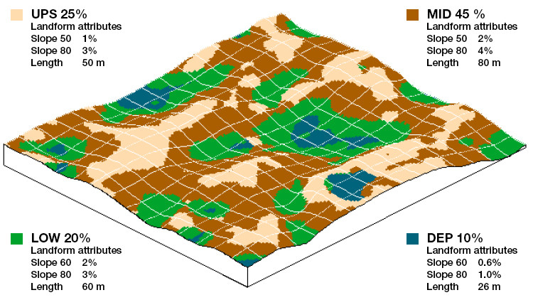
Figure 1. Alberta landform attributes, showing dimensions with colour
The analysis in the document is based on high resolution DEMs (5 to 10 m spacing) for areas of 100 to 200 ha in size (minimum of 1/4 section). The results are then related to 53 landform types identified in the 1:100,000 soil survey database for Alberta, Canada.
Morphometric descriptions are provided for the landform as a whole and for 4 defined landform segments (upper, mid, lower and depression) within each landform type.
The quantitative data provide necessary input for deterministic models and extend the utility of the soil survey databases in Alberta.